Saturday, 21 March 2015

Another Early Close-up Map of Singapore: Manuel Godinho de Erédia, 1615

Name: Folio 26, Historia de Servicos com Martiro de Luis Monteiro Coutinho 
Year: 1615
Map maker: Manuel Godinho de Erédia
Manuscript map location: Biblioteca Nacional Lisbon, Cod. 414
Figure 1. A 1615 map that portrays a naval battle on the 1st of Jan. 1577, between the Portuguese and Acehnese just south of present day Pulau Tekong.


Figure 2. Google map of the similar area for reference.
Here is another early map with a close up view of Singapore. This manuscript map comes a few years after the de Bry's map that was mentioned in a earlier blog entry.

What the map (Fig. 1) shows corresponds roughly to the area depicted in the Google map (Fig. 2). The map depicts a naval battle that happened on January 1st, 1577 [1]. In this battle, a Portuguese fleet under Captain-General Mathias de Albuquerque (nephew of Afonso de Albuquerque, the conqueror of Malacca) clashed with a fleet from Aceh at the mouth of the Johor River, just south of Pulau Tekong between Changi and Pengarang. 

This map is from a 1615 manuscript [2] about the life and martyrdom of a Portuguese soldier by the name of Luis Monteiro Coutinho. The manuscript author Manuel Godinho de Erédia is more famous as the author of the Declaracam de Malaca e da India Meridional com Cathay which contains the earliest map that shows Singapore as an island

The busy naval engagement is illustrated in a lively manner with the Portuguese vessels' cannons ablaze and the Acehnese galleys oars in action.   

On the map (Fig, 1) are written several words. They are listed below with the modern references: 
A. Barubuquet : Berbukit (In malay, it means rolling hills). In later maps, the Europeans typically mistook it as the name of the hill that is present day Bukit Pelali. They could also have mistook it for Bukit Pengarang) 
B. Chani : Changi (Present day Pulau Tekong)
C. Rio de Jor : Johor River
D. Tanjon Rusa : Tanjong Rusa (Present day Changi Point)
E. Luís Monteiro Coutinho
F. Mathias de Albuquerque


There are some other interesting points to note which seem to demonstrate the accuracy of this map: The location marked 1. on the map looks like the mouth of Sungei Sebina. The sand bank at 2.  is a common feature in a lot of later maps of Singapore. Nowadays this sandbank does not appear on maps as it has been subsumed under the land reclamation that is Changi Airport today. Could this small island marked 3. be representing Pulau Ubin?

References
[1] P. J. de Sousa Pinto, The Portuguese and the Straits of Melaka, 1575-1619  (NUS Press, Singapore, 2012) pp 276-278.
[2] A pdf file of Historia de Servicos com Martiro de Luis Monteiro Coutinho can be download from this link.

Sunday, 8 March 2015

The Earliest Close-up Map of Singapore: de Bry, 1606

Name: Contrafactur des Scharmutz els der Holander... (from Achter Theil der Orientalischen Indien, Frankfurt am Main) 
Year: 1606
Publisher: Johan Theodor de Bry, Johan Israel de Bry & Johan Dieterich de Bry

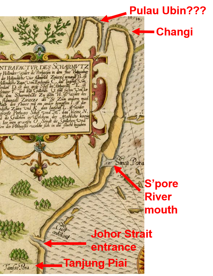
Figure 1. (L) De Bry's 1607 map featuring a sea battle off the Changi coast. Source image link.  (R) Google map of the similar area for reference. 
The subject of this map is a naval battle that happened on the 10th-11th of October 1603, off the coast of Changi point, Singapore. It would probably be more instructive to understand the location as the mouth of the Johor River. 

This is the earliest known map that provides a close-up view of Singapore. The Google map on the right (Fig. 1 (R)) gives you an idea of the orientation and geographical location of what the de Bry map is depicting. 

Fig. 2. Close-up view of the de Bry map in Fig. 1(L).

In this map, Singapore is not shown to be an island. However the general outline of the south coast of Singapore is reasonably accurate, from Tuas, in the west to Changi in the east. Fig. 2 shows an enlarged view of part of the map in Fig. 1(L) with some the geographical locations identified.

Below are some of the location names marked on the map in Fig. 1(L), and their present day names. 

Oudt Ior : Old Johor. Johor Lama

Rio Batasubar : Present name: Johor River. Batasubar refers to Batu Sawar, the capital of the Johor Sultanate during that time. 

Sinca Pora: Singapura. Likely the mouth of Singapore River

Tansse Pora: Tanjung Buru. Present name: Tanjung Piai, Johor, the southernmost point of the Eurasia landmass

The purpose of the map is not to portray Singapore or Johor river mouth's geography, but to detail a naval encounter between the two dominant naval powers of the day. But why were they battling off the coast of a small island thousands of miles away from their home ground?

The Portuguese and the Dutch were then fighting for supremacy for Melaka Straits and the waters off Singapore. Since their first venture to these waters at the end of the 16th century, the Dutch has been slowly eating away the Portuguese dominance of these waters. The Portuguese had been the dominant power there since conquering Melaka in 1511. The Dutch and Portuguese formed shifting alliances with the local powers of Johor (direct successor to the Melaka sultanate) and Aceh, and engaged in a series of skirmishes through the early 17th century. One major incident was the Dutch seizure of a richly laden Portuguese carrack Santa Catarina off the waters of Singapore in Febuaury 1603 with the help of the Johor sultanate.   

In response, a Portuguese armada under Estêvão Teixeira de Macedo blockaded the mouth of the Johor River (where Changi and Pulayu Tekong are located) to punish the Johor sultanate then based in Batu Sawar, as well as to protect their carracks like Santa Catarina plying the Macau-Melaka trade route, lest they fall prey to the Dutch and Johoreans. A passing fleet of Dutch ships under Vice-Admiral Jacob Pietersz van Enkhuysen, responding to a request by the Johoreans to help lift the blockade, decided to engage the Portuguese fleet. The naval battle lasted from the 10th-11th of October 1603 and resulted in a Dutch victory.

For a much more detailed analysis of the origin and ramification, and blow by blow account of this naval encounter, do read the excellent book by NUS historian Peter Borschberg, entitled The Singapore and Melaka Straits [1]. 

Les Petit Voyages is a series of books that described the various early voyages to the East Indies. The work was initiated by a German publisher based in Frankfurt am Main, Theodor de Bry (1528-1498), and was continued after his death by his descendants. 

The map described in this entry is from the appendix of the eighth book of the Les Petit Voyages series. The book was published by Theodor de Bry's sons Johan Theodor and Johan Israel. There is a German edition (1606): Achter Theil der Orientalischen Indien, and a Latin edition (1607) [2]: Indiae Orientalis Pars Octava, published in 1607. 

From the coastline details and the presence of depth readings on the map, I am guessing that this map was probably derived from an actual navigation chart.

References
[1] P. Borschberg, The Singapore and Melaka Straits: Violence, Security and Diplomacy in the 17th Century  (NUS Press, Singapore, 2013) pp 79-88.
[2] A pdf file of Achter Theil der Orientalischen Indien can be download from this link.

Sunday, 15 February 2015

The Oldest Map in the National Library Collection

Name: Undecima Asiae Tabula (from Geographia)
Year: 1478
Map maker: Arnold Buckinck
Type: Copper Engraving

Picture Source: National Library of Singapore

This 1478 map is the oldest item in Singapore's National Library Collection.

You can now take a look at this map, which is prominently showcased in the Land of Gold and Spice Map exhibition. It was part of a lot acquired at a Sotheby's auction in May 2012.


The map's name is Undecima Asiae Tabula or Asia Table No. 11 from Ptolemy's Geographia.

Claudius Ptolemy (90-168 A.D) from Alexandra, Egypt was at one time in charge of Alexandra's legendary Library. One of his major written works was GeographiaGeographia is about map making principles and methods and tables, with locations (latitude and longtitude in degrees and minutes) of over eight thousand places [1]. 

His work, after passing through the Islamic and Byzantium civilizations (where it was revised with information added) over the successive centuries, appeared in Europe in the early 15th century. Geographia then dominated map making for more than a century until the latest details of the Portuguese (and other subsequent European) exploration voyages rendered Geographia obsolete.

It is not known if Ptolemy had any maps in his original Geographia. In any case, renaissance scholars managed to reconstitute a series of maps from the tables of locations compiled in Geographia

With the printing press invented barely twenty years before, the first edition of Geographia with the reconstituted maps was published in Rome in 1477 [2], thereby becoming the first ever printed atlas of the world [3]. The map here is from the second edition published in 1478. The work of creating these first ever printed versions of Geographia was started by Conrad Swehnheym, but was finally completed by Arnold Buckinck after Swehnheym's death.  

The series of maps contain twelve maps on Asia, in which the eleventh map (hence the name Undecima Asiae Tabula) depicts India beyond the Ganges River (INDIA EXTRA GANGEM) and China (SINA). One other geographical feature, that of a peninsula, is of interest to us.

The peninsula is labeled AUREA CHERSONESUS which means the Golden Peninsula, and is typically acknowledged to be the Malay Peninsula [1].  If we look at the southern tip of AUREA CHERSONESUS, we can see SABANA EMPORIUM (Emporium means trading post). Now, if AUREA CHERSONESUS is indeed the Malay Peninsula, then it will be tempting to say that SABANA EMPORIUM is Singapore. 


However, there is nothing to prove that SABANA EMPORIUM is indeed Singapore. The fact is that it could be any number of places on the coast of the Malay Peninsula or the islands of the Riau Archipelago [1]. Speculations of the location of Sabana include Sabak Bernam, in Selangor, Kundur Island in the Riau Archipelago and Sabana River Sungei Sebina, a tributary of Johor River. Until some Roman era artifacts are found in Singapore, or any of the other locations, we will never know for sure.

References
[1] P. Wheatley, The Golden Khersonese (University of Malaya Press, Kuala Lumpur, 1961). Chap. X.
[2] T. Suarez, Early Mapping of Southeast Asia (Periplus, Singapore, 1999). p. 82
[3] Barry Lawrence Ruderman Antique Maps Inc. accessed 20150215.

Sunday, 8 February 2015

When did Singapore become an island? Part III

To the best of my knowledge, 1613*.


In Manuel Godinho de Erédia's Declaracam de Malaca e da India Meridional com Cathay [1], there is a series of manuscript maps portraying Singapore as an island. These are the first instances where Singapore appears distinctly as an island on a map, instead of as a cape or promontory.  


Name: JOR: Regno. [Folio 45R, Declaracam de Malaca e da India Meridional com Cathay].
Year: 1613
Map Maker: Manuel Godinho de Erédia
Manuscript map location: Bibliothèque royale de Belgique, Brussels, Belgium. Ms. 7264.
Figure 1. (Left) Eredia's map JOR: Regno, where Singapore (SINCAPURA) appears, for the first time, as an island. Source: [2]. (Right) Screen capture from Google map of the area for reference. 
This manuscript map (Fig. 1) is oriented south-north and shows the southern end of the Malay peninsula. It shows an oversized Rio de Jor (Johor River), where the Johor Kingdom (JOR: Regno) is based along. An island labeled SINCAPURA sits at the mouth of the Johor River. Another interesting feature is the island below SINCAPURA which is labeled Pulochagni. This probably means Pulau Changi, and is the old name for Pulau Tekong.


Name: Discripsao chorographica dos Estreitos de Sincapura e Sabbam. Ano 1604. [Folio 61R, Declaracam de Malaca e da India Meridional com Cathay].
Year: 1613
Map Maker: Manuel Godinho de Erédia
Manuscript map location: Bibliothèque royale de Belgique, Brussels, Belgium. Ms. 7264.
Figure 2. (Left) Eredia's map Discripsao chorographica dos Estreitos de Sincapura e Sabbam. Ano 1604. The island of SINCAPURA appears in the southwest corner of the map. Several place names on Singapore island are labeled (See Fig. 3). Source: [3]. (Right) Screen capture from Google map of the area for reference. 
This map entitled Discripsao chorographica dos Estreitos de Sincapura e Sabbam. Ano 1604 (Chronological description of the Straits of Singapore and Sabbam. A.D. 1604) is a close up version of the the map in Fig. 1 placing the strategically important straits south of Singapore in the centre stage. Several places on Singapore island are also labeled (See Fig. 3 for details). Comparing with the map of the Google map on the right, it is clear that Eredia got the shape of Singapore island wrong. The places labeled on the coast of Singapore island facing the east according to the map, should instead be on the south side of the island.

Figure 3. Close up view of SINCAPURA island (from Fig. 2).
The map in Fig. 2 also shows that some of the current familiar place names in Singapore dates back more than four hundred years ago. Here's the list of names labeled in Fig. 3 and their modern names and identifications:

blacan mati : Pulau Blakang Mati, old name of Sentosa island. Although the location of this island on the map does not fit the location of Sentosa island. My guess is that either Eredia got the island wrong, or that another southern island bore the name of Blakang Mati four hundred years ago.

estreito nouo : New Straits. Channel that passes south of Sentosa island [4]. 

estreito Velho : Old Straits. Present day straits between Sentosa and Singapore island, where Keppel harbour is. The island on the map between estreito nouo and estreito Velho should be Sentosa island.

xabandaria : Shahbandar. (Persian word for harbour master). Settlement around the shahbandar official loyal to the Johor sultanate. The location is either near the mouth of Singapore River or Kallang basin [5]. 

Tanjon Rû : Tanjong Rhu

Sunebodo : Sungei Bedok

Tanamera : Tanah Merah

Tanjon Rusa : Tanjong Rusa. Obsolete place name. Probably present day Changi Point.

Turucan: Terusan (Malay word for Channel)

Salat Tubro : Selat Tebrau (Tebrau Straits that separates Singapore and Malaysia)

Pulo Ular : Pulau Ular (Snake island). Now known as Pulau Merambong


Manuel Godinho de Erédia (1563-1623) was born in Malacca of Ibero-Bugis parentage. Educated in Malacca and Goa, he was commissioned in 1594 as the Descobridor e Adelantado da Nova India Meridional. His assignment was to set out from Malacca to discover for Portugal, new lands south of the East Indies. However, that did not quite work out. 

Right during that time, the Straits of Malacca became a geopolitical hotspot as the Dutch became active in the region. The Dutch, allied with the Johor Sultanate, were challenging the Portuguese dominance of the Straits of Malacca. Instead of setting out to explore the unknown seas, Eredia had to help out with the fortification and survey of the region. This led to a more detailed exploration of the strategically important waters around Singapore.

This new information gained, together with the new maps drawn were eventually written up by Eredia in 1613 as his Declaracam de Malaca e da India Meridional com Cathay, more commonly known as Description of Malaca.


*Added 24th Sept.: There are several manuscript maps dating from the 1530s onwards that show Singapore as an island, but unnamed. See this entry.  

References
[1] J. V. Mills, "Description of Malaca, Meridional India, and Cathay. Translated from Portuguese with notes". JMBRAS 8, 1 (1930).
[2] ibid. Plate III, after p. 218.
[3] ibid. Plate VI, after p. 224.
[4] P. Borschberg, The Singapore and Melaka Straits: Violence, Security and Diplomacy in the 17th Century  (NUS Press, Singapore, 2013) p. 31
[5] ed. P. Borschberg, trans. R. Roy, The Memoirs and Memorials of Jacques de Coutre: Security, Trade and Society in 16th- and 17th-century Southeast Asia (NUS Press, Singapore, 2013) p. 378.

Saturday, 7 February 2015

When did Singapore become an island? Part II

In a previous entry, we talked about an 'island' feature at the southern end of the Malay peninsula that appeared in many maps dating from the mid 1500s to 1620s. This 'island' is evidently not the island of Singapore. So what is it?

On closer look at some of these maps, the 'strait' that separates the island from the peninsula is more like a river or canal. One good example is the Willem Lodewycksz's 1598 map (Fig. 1). The waterway has its western and eastern termini at Muar and Paham, respectively. The town of Muar in the Malaysian state of Johor is still around and Paham is synonymous to Pahang a state in present day  Malaysia. 

On the northern and southern banks of the waterway are written R Fermoso and Muar R. R has to mean either 'rivier' or 'rio' (dutch and portuguese for river). Obviously the mapmaker believes that a river links the Straits of Malacca to the South China Sea. But what is the basis of this feature?   

Figure1. Close up look at Willem Lodewycksz's 1598 map. Full picture link.

This waterway is attributed to the presence of an ancient trans-peninsular route [1]. This route was used and known by the locals since ancient times.  This route connects the Muar river system that flows into the Malacca Straits in the west coast of the peninsular, and the Pahang river system that flows into the South China Sea on the east coast of the peninsular. On Fig. 2 is the trace of this trade route.  

One can access this route from the mouth of the Sungei Muar. Following the river upstream, one eventually reached the fork where Sungei Muar meets one of its tributary, Sungei Jempol. This place is near to present day Bahau, Negri Sembilan. At a point a few hundred metres upstream on Sungei Jempol, one can land on the northern bank and follow a dragway or portage of less than one kilometre to reach another river, Sungei Serting. Sungei Serting then winds its way through Negri Sembilan into Pahang state, joins Sungei Bara, which eventually flows into the large river of Sungei Pahang. The town at the mouth of Pahang River is presently known as Pekan, and is probably the old Paham on Lodewycksz's map (Fig. 1). 


Figure 2. The  southern part of the Malay Peninsula from Google map. The red line denotes Sungei Muar-Sungei Jempol river system, while the blue line denotes the Sungei Serting-Sungei Bara-Sungei Pahang river system. Zoom in at the red balloon where the red and blue line meet to find the Jalan Penarikan.


This dragway that connects Sungei Jempol with Sungei Serting is the famous Jalan Penarikan. Penarikan is derived from the word 'tarik', which is the Malay word for 'pull' [2]. The Portuguese who  were in control of Malacca from 1511 to 1641 knew of this dragway, as evidenced by a 1602 map by Godinha de Eredia. Near the top right corner of the map is written Panarican which connects Jompol and Sertin (See Fig. 3).

Name: Nova tavoa geographica da tera do sertam de Malaca (New Geographic Map of the Interior of Malaca)
Year Published: 16o2
Map Maker: Godinho de Eredia
Manuscript map location: Biblioteca Nacional do Brasil

Figure 3. Nova tavoa geographica da tera do sertam de Malaca (New Geographic Map of the Interior of Malaca), dated to 1602, by Godinho de Eredia. This may be the oldest extant map of Malacca territory. Shown within the black square is a Panarican that connects Jompol and Sertin. Picture source file.  

From the map (Fig. 2) that traces the route, it is not difficult to imagine how the travelers and map makers extrapolate this route, which is mainly a river system with a few hundred meter overland journey, into a major water way. This thereby creates the 'island' feature on the many old maps of the Malay Peninsula. 

So back to question of when did Singapore really appear as an island on maps? This will be answered in the next entry.

References

[1] P. Wheatley, The Golden Khersonese (University of Malaya Press, Kuala Lumpur, 1961). 
[2] Check out this video to see how the Penarikan looks like today:


Monday, 26 January 2015

The David Parry Southeast Asian Map Collection

The David Parry SE Asian Map Collection forms the main body of the current map exhibition in National Library on the early maps of SE Asia and Singapore, entitled 'The Land of Gold and Spices'.


The entire collection comprises 254 maps of Southeast Asia, with emphasis on the islands that make up present day Indonesia. The oldest map in the collection is a 1478 Ptolemaic map of South East Asia, Tabula Asiae XI from Arnold Buckinck's edition of Ptolemy's Geopgraphia [1]. Other maps from mapmakers such as Fries, Ruscelli, Ortelius, Linschoten, Mercator, Dudley, Blaeu, De Wit, Coronelli, Thornton, Moll, Bellin, Bonne, Valentijn etc. traced the development of the mapping of Southeast Asia from the 1500s to 1800s.

The collection was acquired by the National Library of Singapore at a Sotheby's auction in May 2012 at a price of GBP223,250 (or about SGD448,700 at the conversion rate in May 2012).

Snapshot from Sotheby's webpage. The map shown is one of the highlight of the collection:  A Map  of the East Indies and adjacent countries; with the settlements, factories and territories, explaining what belongs to England, France, Holland, Denmark, Portugal &c. by Herman Moll,  London, 1717.
David Parry is a soil scientist and has worked and lived in  Indonesia (the former Dutch East Indies) for much of his life. He started to assemble his map collection in the early 1980s. He is the author of the book The Cartography of The East Indian Islands: Insulae Indiae Orientalis (Countrywide Editions, London, 2005).

References
[1] With the acquisition, this map became the oldest article in the collection of National Library of Singapore, according to the exhibition curator, Tan Huism. 

Friday, 23 January 2015

When did Singapore become an island? Part I

On the earliest printed maps that feature Singapore, there is no indication that cartographers realized that it is an island. In fact, Singapore was usually depicted as a cape. The map (Fig. 1) below is an example. The map India Tercera Nova Tabula is from the Venetian mapmaker Giacomo Gastaldi's edition of Ptolemy's Geographia. It features Southeast Asia, with the Malay peninsula appearing near the middle of the map. 

Name: India Tercera Nova Tabula (from Gastaldi's edition of Ptolemy's Geographia)
Year: 1548
Mapmaker/publisher: Giacomo Gastaldi
Type: Copper Engraving

Figure 1. India Tercera Nova Tabula. Picture source link.
Fig. 2 is a close up look near the middle of the map, where the Malay peninsula is.


Figure 2.. 
Near the bottom right of the map in Fig. 2, one can read C. Cincapula. Cincapula no doubt denotes Singapura, while the C. denotes 'Capo' or cape in italian.


This map is also of interest, as it is the second earliest printed map to feature a variant of the Singapore toponym [1].

There are also examples of many other maps where Singapore is presented as a cape, such as...
 

Name: India Terza Ostro Tavola (from Vol. 1 of Ramusio's Delle Navigation  Viaggi
Year: 1554
Mapmaker/publisher: Giacomo Gastaldi and Giovanni Battista Ramusio
Type: Woodcut


Figure 3. Terza Ostro Tavola by Giovanni Ramusio. Picture source link.
In this map by Ramusio, the orientation is south-north instead of the more usual north-south. This map is notable for being one of the first maps to feature the Philippines. But that is not what we are interested in here. What we are interested in here, the Malay peninsula, is this 'leg' like feature on the right of the figure, jutting upwards. Figure 4 is a close up view of the tip of the peninsula. At the extreme tip and you will see C. de cimcapula. Again, we have Singapore as a cape in this map. 

What is more intriguing is that right beside C. de cimcapula, there is an island. Is Ramusio trying to depict the the island of Singapore? 

Figure 4. Close up view of the tip of 
Probably not. Firstly, the island is way too big to be Singapore island. Secondly, Muar is written on the island, not Cimcapula.  


If it was just this one map, it could easily be attributed to this cartographer's imagination. However, it turns out that there are too many maps that have this 'too-big-to-be-Singapore' island feature to consign it to simply an 'artist's impression'.

According to NUS historian Peter Borschberg, this feature appeared as early as 1537 [2]. This feature persisted and appeared on maps published as late as 1623 [3].

Here are some examples of important and famous maps that have this 'too-big-to-be-Singapore' island feature.


Figure 5. This is a close up look of the map of Southeast Asia from Jan Huygen van Linschoten's Itinerario. the North-south axis of map is along the horizontal direction. This is the English version dated to 1598. Picture source link
Name: Nova tabula insularum Iavae, Sumatrae, Borneonis et aliarum Malaccam usque, delineata in insula Iava, ubi ad vivum designantur vada et brevia scopulique interjacentes descripta (from  Part II of Theodore de Bry's Petits Voyage)
Year: 1598
Mapmaker: Willem Lodewycksz
Type: Copper Engraving

Figure 6. Willem Lodewycksz's  Nova tabula insularum Iavae, Sumatrae, Borneonis...etc... The above map is part of the collection of the National Library of Singapore. See source link.
So, if this feature does not represent Singapore island, then what does it represent? 

That will be the question that we will try to answer in a future blog entry.


References

[1] T. Suarez, Early Mapping of Southeast Asia (Periplus, Singapore, 1999). p. 104 
[2] P. Borschberg, 'Singapura in Early Modern Cartography: A Sea of Challenges' in Visualising Space: Maps of Singapore and the Region (National  Library Board, Singapore, 2015) 
[3] P. Wheatley, The Golden Khersonese (University of Malaya Press, Kuala Lumpur, 1961). p. 165.