Sunday, 20 March 2016

Some Treasures at the Museum Nasional, Jakarta

One of best things I did during my visits to Jakarta was to visit the treasure-filled National Museum of Indonesia (Museum Nasional). Here, I will mention a few of these treasures that are somewhat related to Singapore.

The front view of the Museum Nasional in Jakarta.

The Gajah Sculpture
The main museum building is also known locally as the Gedung Gajah or elephant building. It is named so because of the elephant statue standing in front of the building. This bronze elephant is a gift from King Chulalongkorn of Thailand during his visit to Batavia in 1871. This elephant has a twin in Singapore, which sits right in front of Singapore's old Parliament House (currently called the Arts House). 


The elephant twins. Gifts from Chulalongkorn to (L) Batavia and (R) Singapore during his first trip overseas in 1871.

The Thai King Rama V, better known as Chulalongkorn, made a trip (the very first overseas trip by a Thai monarch) to Singapore and Batavia in 1871 from 9 March-15 April [1]This pair of handsome elephant statues were gifts from Chulalongkorn to Batavia and Singapore, respectively, to commemorate the visits. 

Raffles' Bust
Bust of Stamford Raffles
In a room immediately to the left after the main entrance of the old wing, where some of the old colonial artefacts are placed, is a bronze bust statue of Sir Stamford Raffles. This bust is probably the 1929 copy commissioned by the Royal Batavian Society of Arts and Sciences (Koninklijk Bataviaasch Genootschap van Kunsten en Wetenschappen) for their 150th anniversary celebration [2]. This society and the collections that it amassed formed the basis of the National Museum of Indonesia. This bust is a copy of the famous Chantrey bust in the collection of the London Zoological Society. 

From 1811 till 1816, Raffles was the Lieutenant-Governor of Java. He was also deeply interested in the culture of Java. In 1813, he helped revive the society (then known as the Bataviaasch Genootschap der Konsten en Wetenschappen or the Batavian Society of Arts and Sciences), and was made president of the society [3].   

Kota Kapur Inscription
On this stone is inscribed the oldest known dated writings in the Malay language. This stone inscription was found at Kota Kapur on Bangka island and is dated to 686 CE. During this time, the area was under the suzerainty of the Srivijaya empire. The Old Malay was inscribed in the Later Pallava script, and contains a curse against those who do evil and who are disloyal to the King. It also talks about the King's planned invasion of Bhumi to subject it to Srivijaya's rule [4]. Old Malay is the direct ancestor of Bahasa Indonesia (official language of Indonesia) and Bahasa Melayu (official/national language of Malaysia, Brunei and Singapore), which are essentially the same language. Well, to be exact, Bahasa Melayu is the national language and one of the official languages in Singapore. 


(L). The Kota Kapur Inscription. Dated 686 CE. (R) A closer look at the inscribed Pallava script.

Also of interest is another stone inscription near the Museum entrance, known as the Telagabatu Inscription, written also in the Old Malay language using the Later Pallava script. This inscription is also dated to the 7th century CE.


Regalia of the Riau-Lingga Sultanate
On the fourth level of the new wing (this level is only accessible by elevator, and seems to be missed by most visitors) is the Treasures and Ceramics gallery.

In this gallery are exhibited many artefacts which were the heirlooms of by-gone sultanates which were annexed by the Dutch when they were in power. One of these defunct sultanates that has their regalia housed here is the Riau-Lingga Sultanate. The Riau-Lingga Sultanate royal regalia on display [5] includes two jogan (ritual fans or State lances by different accounts), one silver and one gold. There are also two pedang (swords) on display.     

Items of the royal regalia of the Riau-Lingga Sultanate. (L) The silver Jogan and (R) the gold Jogan (picture taken from [5]). Written on the gold Jogan is the claimed lineage of the sultan, and how he has the legitimacy of rule over the Tanah Melayu ...etc... [6].

How are these items related to Singapore's history? In Feb. 1819, in order to have someone pliable to sign a 'Treaty of Friendship and Alliance' to set up a trading post in Singapore, Raffles effectively installed Tengku Hussein as the Sultan of Johor and Singapore. This was done when there was already a Sultan Abdul Rahman, who as the Sultan of Johor-Riau, was supposed to reign over Singapore as well. 

How did Raffles manage to pull it off? Well, things were not so straightforward. Since the previous Sultan, Mahmud died in 1812, different factions in the royal court supporting either Tengku Abdul Rahman or Tengku Hussein had been jockeying and trying to install their own candidate as sultan. Abdul Rahman, the younger half-brother of Hussein, won out with the support of the Dutch and the Bugis. Now, one of the list of things you need to check off if you want to be properly installed as a Sultan is to have the royal Regalia in your possession. Unfortunately for Abdul Rahman, the royal Regalia was under the custody of Engku Puteri Rajah Hamida, who was the main royal wife of Sultan Mahmud (Abdul Rahman and Hussein were sons of two minor commoner wives of Mahmud). She did not accept the legitimacy of Abdul Rahman's installation as sultan, and refused to hand over the Royal Regalia. And so the succession dispute dragged on for years. 

In early 1819, as it would not be possible to sign a treaty with Sultan Abdul Rahman who was under the thumb of the Dutch, rivals to the British commercial interests, Raffles and company seized this opportunity to their advantage to install their own puppet sultan whom they could then 'legally' sign a treaty with.  

Eventually, when all the dust had settled when the 'higher powers' in Europe thrashed out the 1824 Anglo-Dutch treaty, the erstwhile Riau-Johor Sultanate was partitioned into the Riau-Lingga and Johor-Singapore Sultanates, under the Dutch and British spheres of influence, respectively.  

The royal regalia was later taken forcibly away from Engku Puteri Rajah Hamida by the Dutch to give to Sultan Abdul Rahman. The Riau-Lingga sultanate was annexed by the Dutch in 1911, and the regalia eventually ended up in the museum's collection. 

It is not known exactly when these items on display were made and they could have been made post-1819 (the labels were not very specific about the ages of these artefacts). However it is probable and I would like to think that they were part of the regalia that was withheld by Engku Puteri Rajah Hamida in the dramatic days of 1810s and that I am looking at artefacts that had a role in the founding of modern Singapore. I suppose these artefacts could go even further back in time and originated from the Malacca sultanate. Pure speculations.

And if you have some time to spare after the museum trip, do drop by the nearby Museum Taman Prasasti to take a look at the tombs of Olivia Raffles and John Leyden. 

References
[1] Lim, Patricia Pui Hue, Through the eyes of the King : the travels of King Chulalongkorn to Malaya (Institute of Southeast Asian Studies, Singapore, 2009).
[2] Bonny Tan, "Raffles' Bust" from Singapore Infopedia (National Library Board, Singapore, 2005). link
[3] John N. Miksic (Ed.), Icons of Art: The Collections of the National Museum of Indonesia (BAB Publishing, Jakarta2007) p. 47.
[4] ibid. pp. 102-103
[5] ibid. p. 143
[6] During my first visit to the museum in Oct. 2012, I could only take the pictures of the silver Jogan as the gold Jogan was out on loan. During my second visit in Oct. 2014, I finally got to see the gold Jogan. Unfortunately, this time round, no photography was allowed due to security reasons, presumably because of the recent burglary from the National Museum (see link here). In its place, I pinched a picture from [5].

Dates of visits: 7th Oct. 2012, & 12th Oct. 2014

Thursday, 24 September 2015

When did Singapore become an island? Part IV

Peter Borschberg has written an excellent article on the early mapping of Singapore [1]. This article is part of the book published in conjunction with the recently concluded Geo|Graphic: Celebrating maps and their stories exhibition at the National Library of Singapore. I learnt a great deal from the article.

Although the earliest known maps that clearly labels the present island of Singapore with a name, only came about at the beginning of 1600s (See earlier post), there are several manuscript maps in the 1500s covering the Malay peninsula, that already features what is very likely to be present day Singapore island, albeit unnamed [1]. 

One of the earliest of such maps, according to Borschberg [1], is a 1537 portolan map by Portuguese Gaspar Viegas.

Name: Carta nautica dell'Estremo Oriente
Year: 1537
Mapmaker: Gaspar Viegas
Manuscript location: Bibloteca Riccardiana, Florence, Italy

Figure 1. Carta nautica dell'Estremo Oriente, by Gaspar Viegas, 1537. One of the earliest charts that features an island (painted in gold and unnamed. Circled in blue) that is probably the island of Singapore. Image source: Biblioteca Riccardiana.
Interestingly, simultaneous with the appearance of Singapore island on these maps, is the appearance of the Muar-Pahang trans-peninsula river-penarikan system [2]. You can clearly see it in the Viegas map above as the sinusoidal waterway that cuts across the Malay peninsular. 

References

[1] P. Borschberg "Singapore in Early Modern Cartography: A Sea of Challenge", Visualising Space: Maps of Singapore and the Region, (National  Library Board, Singapore, 2015), pp 6-33.
[2] P. Wheatley "A curious feature on early maps of Malaya", Imago Mundi, 11 (1954), pp. 67-72.

Saturday, 1 August 2015

Where Olivia Mariamne Raffles and John Caspar Leyden rest...

About 10 minutes walk from the National Museum of Indonesia in Jakarta, by Jalan Tanah Abang, is a small cemetery, or what is left of a bigger one. Nowadays, it is known as the Museum Taman Prasasti (Park of Memorial Stones Museum). It is the remnant of the old European cemetery. This is where many luminaries of old colonial era Batavia still rest [1].


Entrance of the Museum Taman Prasasti, Jalan Tanah Abang, Jakarta.
From 1811 till 1815, Java was under the colonial rule of the British, and Thomas Stamford Raffles was the Lieutenant-Governor. During that period, two persons dearest to him died and were buried here.

John Casper Leyden (1775-1811)


John Caspar Leyden. Picture Source.
Leyden was a great friend of Stamford Raffles and his first wife, Olivia. Leyden is most famous for his translation into English, of Sulalatus Salatin, more popularly known as Sejarah Melayu or Malay Annals [2]. Stamford Raffles and Olivia first met him in 1805 in Penang [3]. Leyden was already an established scholar when they met, and the two men hit it off right away. Raffles, who had not much formal education gained much from his teacher/friend. Leyden was the catalyst to Raffles later scholarly pursuits of the history, culture and politics of the Malay world, which Singapore was part of.  The fact that Raffles knew about the ancient pedigree of Singapore may have been a contributing factor to Raffles' choice of Singapore as the trading post in 1819.


Title page of Malay Annals. Translated by John Leyden. Published posthumously in 1821, with a foreword by Sir Thomas Stamford Raffles. (from my private collection)
Leyden died not too long after the British invaded Java in 1811 [4]. His grave is a rectangular platform, with two plaques on the top. This present grave is probably not the original one, as the marble slab platform looks like a modern day patch job.  


John Leyden's grave at Museum Taman Prasasti. 
The top plaque reads... 
SACRED
TO THE MEMORY OF
JOHN CASPER LEYDEN MD
WHO WAS BORN
AT TEVIOTDALE IN SCOTLAND
AND WHO DIED
IN THE PRIME OF LIFE
AT MOLENVLIET NEAR BATAVIA
ON THE 28TH AUGUST 1811
TWO DAYS
AFTER THE FALL OF CORNELIS

while the bottom plaque reads...


THE POETICAL TALENTS AND SUPERIOR LITERARY

ATTAINMENTS OF DR LEYDEN, RENDERED HIM A
ORNAMENT OF THE AGE IN WHICH HE LIVED_
HIS ARDENT SPIRIT AND INSATIABLE THIRST AFTER
KNOWLEDGE WAS PERHAPS UNEQUALLED
AND THE FRIEND OF SCIENCE MUST EVER
DEPLORE HIS UNTIMELY FATE_
HIS PRINCIPLES AS A MAN WERE PURE AND SPOTLESS_
AND AS A FRIEND HE WAS FIRM AND SINCERE
_ FEW HAVE PASSED THROUGH THIS LIFE
WITH FEWER VICES OR WITH A GREATER
PROSPECT OF HAPPINESS IN THE NEXT


Right beside Leyden's grave, lies Olivia, the first wife of Stamford Raffles.

Olivia Mariamne Raffles (1771-1814)


Raffles' first wife was Olivia Mariamne Fancourt née Devenish. They got married in March 1805, one month before they set off for Penang, where Stamford Raffles was to serve as Assistant Secretary to the Governor in the new Presidency in George Town on Prince of Wales Island (Penang). Olivia had an earlier marriage with Jacob Cassivelaun Fancourt, an assistant surgeon in Madras which ended with Jacob's death in 1800. Olivia then went back to Great Britain where she later met Raffles. She seems to have led quite a colourful life before meeting Raffles and there are plenty of interesting stories and rumours about Olivia during her younger days.    

By all accounts, the Raffles couple had a very loving relationship, and when Raffles became the Lieutenant-Governor of Java, she made an excellent 'first lady' that gave much grace and dignity to the office. 

The Governor's mansion in Bogor (then known as Buitenzorg) where Thomas Stamford and Olivia Mariamne Raffles held court. Today, it seats in the lovely Kebun Raya Bogor (Bogor Botanical Gardens). (Photo taken 9th Oct. 2008)  


When she died suddenly in Buitenzorg (Present day Bogor) on the 26th November 1814, Raffles was devastated. It came near the end of Raffles' tumultuous tenure as the lieutenant-governor of Java. Stressed and overworked, coupled with the sudden loss of Olivia, Raffles fell seriously ill, and his friends feared for his life. He survived [5]. 

Olivia was laid to rest right beside John Leyden. The tomb seats on a raised octogonal platform. There used to be a roof sheltering the gravestone, supported by eight pillars [1]. The roof has since collapsed and the pillars shortened to become the stumps that you see in the photo. 
  
Tomb of Olivia Mariamne Raffles in Museum Taman Prasasti, Jakarta. At the left end of the picture, you can see Leyden's tomb. 
On the plaque laid on the tomb, it is carved:


SACRED
To the Memory of
OLIVIA MARIAMNE
Wife of
The Hon'ble THOMAS STAMFORD RAFFLES
Lieutenant Govenor
OF JAVA
and its Dependencies
Who departed this life in
Buitenzorg
the 25th day of November 1814

Most people will probably be more familiar with the memorial that Raffles commissioned, in memory of Olivia. This graceful edifice is on the grounds of the Governor's mansion in Buitenzorg, where the couple had so much sweet memories. Today, it is located within the Kebun Raya Bogor (Bogor Botanical Gardens).


The memorial to Olivia Mariamne Raffles on the grounds of the Kebun Raya Bogor (Bogor Botanical Gardens). Erected by Raffles. (Photo taken 9th Oct. 2008) 

References
[1] A. Heuken SJ, Historical Sites of Jakarta (Cipta Loka Caraka, Jakarta, 2007) Chap. XI
[2] C.E. Wurtzburg, Raffles of the Eastern Isles (Hodder and Stoughton, London, 1954), p. 36
[3] J. Leyden (trans.), Malay Annals (Longman, Hurst, Rees, Orme, and Brown, London, 1821)
[4] C.E. Wurtzburg, Raffles of the Eastern Isles (Hodder and Stoughton, London, 1954), p. 167
[5] ibid. p. 362

Date of Visit: 7th Oct. 2012, & 12th Oct. 2014. (Kebun Raya Bogor, 9th Oct. 2008) 

Sunday, 24 May 2015

Tree Island: The entrance to the Singapore Strait, and a boundary marker

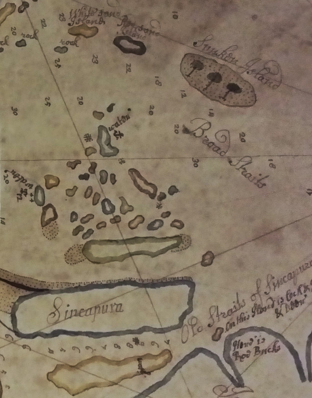
On display at the Land of Gold and Spice (LoGaS) exhibition at the National Library are several Dutch and British navigational charts from the late 17th to late 18th century. Singapore island itself was not of much interest to the chart makers, judging from the inaccurate depiction of the geographical feature of the Singapore island. Instead the main focus of these charts are the waters around Singapore island, which were important, as they connect the South China Sea to the Straits of Malacca, and onwards to the Indian Ocean. Then, as is now,  the waterways south of Singapore were of immense strategic value. The most important waterway is the Singapore strait, also known as Governor's Strait [1].

One recurring feature on these maps is an island drawn with trees on it. Below are some close-up views of these charts/maps.

Figure 1. From a Hand-drawn chart of the southern portion of the Malay Peninsula, the Singapore Straits by Thomas Bowrey, 1690. Collection of the British Library, Add Ms. 5222-10. The chart has South on top and North at the bottom. Sincapura island is a featureless oblong apart from the sand banks emanating off the east end. Towards the top right is the feature with three trees on it, labelled Sunken Island. The Singapore Strait is labelled Broad Straits here. This map is on display in the LoGaS exhibition. 

Figure 2. A figure on pg. 62 from The English Pilot. The Third Book by Samuel Thornton, 1711.  Passage Island is present day Pulau Satumu where Raffles Ligh House is on. The present day Indonesia-Singapore maritime boundary runs between Tree Island (Pulau Nipa) and Passage Island (Pulau Satumu).  
Figure 3. From an untitled chart of the Strait of Singapore, circa 1675-1700. Collection of the Leiden University Library, 006-14-021. Tree island is near the centre of the figure. The island of the top right corner 't Lang Eylant (The Long Island) is Singapore island. This map is on display in the LoGaS exhibition.

Figure 4. From Chart of the Riau and Lingga Archipelago, circa 1725. Collection of the Leiden University Library, 006-14-012. The round feature with three trees on it is labelled Boompjes Eilant (Trees island). This map is interesting as the island of Singapore is labelled Oude Straat Sincapura. This map was on display in the LoGaS exhibition till April 2015.
Figure 5. From Jacques Nicolas Bellin's Carte reduite des detroits de Malaca, Sincapour, et du Gouverneur, 1755.  Tree island is labelled as Banc aux Arbres. This map belongs to the NLB collection and is on display in the LoGaS exhibition.

Figure 6. From A.E. van Braam van Houckgeest's Nauwkeurige kaart van he oostlijk gedeelte van Straat Malacca, circa 1787.  Collection of the Leiden University Library, 006-14-015. The feature with trees on the left is labeled Zaandplaat met de Boomen (sand bank with trees). On the right side is De Straat Gouverneur (Governor's Strait or Singapore Strait).  This map belongs to the NLB collection and is on display in the LoGaS exhibition.
This island came in several names: Tree Island, Boompjes Eilant (which is Tree island in Dutch), Bumkees Island (Corruption of the Dutch name), and Sunken island, to name a few. 

The reason why this island was so clearly marked is because it was a traffic signpost of sorts to signify that one is approaching the safest (and most used)  channel to go from the Straits of Malacca to the open seas of South china Sea, in the otherwise treacherous waters around Singapore island (Figure 7).

From the classic 19th century manual of sailing directions known as the Horsburgh's Sailing Instruction, the section on Singapore Straits reads [2]:

 SINGAPORE STRAIT, called Governor Strait, or New Strait by the French and Portuguese, may be considered to commence at Tree Island...

The Horsburgh's Sailing Instruction went on to describe this island...

...is a bank of rocks and sand very little elevated above the sea at high water, having on it two small trees or bushes, separated from each other.


Figure 7. Google map of the waters off the southern part of Singapore Island. On either side of the Singapore Straits are multitude of islands and sandbanks that were hazards to ships.
This island is now known as Pulau Nipa. Up till less than twenty years ago, this above description would still apply to this island. It had a high tide area of ​​0.62 hectares (about a football field large) but would bloat to an approximate area of 60-hectare during low tide [3] (See Fig. 8). 


Figure 8. The profile of Pulau Nipa during low tide (greenish-yellow) and during high tide (small specks in yellow). From the maritime chart Singapore and Indonesia Main Strait and Phillip Channel, 1990.
Figure 9. How Pulau Nipa looked like before 2003 (looking southward). Picture Source.
Nowadays, Singapore Strait is still heavily used. With better navigation technology, mariners no longer rely on spotting this island to know their directions into the Singapore Strait. 

Now Tree island or Pulau Nipa should have retired from the annals of maritime history. But if you imagine it be an idyllic little island with a clump of nipah palms and coconut trees, and a sandy white beach (Fig. 9), you would be disappointed.  
It gained prominence again not too long time ago. In 2003, there were concerns that the island was in danger of disappearing, because of sand dredging activities around it. As the island is part of the Indonesian archipelagic baseline on which the Singapore-Indonesia international boundary was to based on, it was deemed essential that this island remains an island. Presumably, Indonesia was afraid that Singapore may somehow not recognize a disappeared Pulau Nipa as part of the baseline (Despite the fact that part of the Singapore-Indonesia boundary had already been marked out in a 1973 treaty which used Pulau Nipa as part of the archipelagic base-line). Furthermore, the dredged sand was exported to Singapore for land reclamation work of Tuas and Jurong Island, which no doubt worried Indonesia. 

Therefore, the Indonesian authorities embarked on an extensive land reclamation around Pulau Nipa to raise it permanently above sea level [4].  In any case, Pulau Nipa remained part of the archipelagic base-line used to extend the Singapore-Indonesia maritime boundary n 2009 [5]. Pulau Nipa now assumes a much more permanent existence (See Fig. 10 below), although hopefully in time to come, trees will flourish on it again.


Figure 10. How Pulau Nipa look like after the land reclamations (looking northward). Picture Source.

References
[1] P. Borschberg, The Singapore and Melaka Straits: Violence, Security and Diplomacy in the 17th Century  (NUS Press, Singapore, 2013) p. 36.
[2] James Horsburgh, The India directory, or, Directions for sailing to and from the East Indies, China, Australia, and the interjacent ports of Africa and South America: Originally compiled from the journals of the honourable company's ships, and from Observations and Remarks, resulting from the experience of twenty-one years in the Navigation of those seas.Volume Second. Seventh Edition. (Wm. H. Allen & Co., London, 1855), p. 266.
[3] "Kerasnya Nipa si Pulau Noktah Perbatasan RI", National Geographic Indonesialink.
[4] "Indonesia restores key maritime baseline of Nipah  Island: Foreign Ministry", Jakarta Post. Feb. 5th 2009. link 
[5] "RI, Singapore sign maritime boundary agreement", Jakarta Post. March 11th 2009. link

Sunday, 3 May 2015

Map of Singapore Town, 1881. Sold for $95,000.

Name: Map of Singapore Town shewing building allotments & registered numbers of crown leases
Year: 1881
Map maker: Thambo Peter
Scale: 4 chains to 1 inch (1:3168)
Size: 980 x 1840 mm.

Image source: Bloomsbury Auction 

This map was sold at the Bloomsbury Books and Works on Paper Auction on 30th April 2015. The hammer price was £38,000. If you include the auction house commission, this becomes £47,120, which converts to a cool S$95,389 (according to the latest exchange rates). The hammer price was way higher than the auction house's original estimate of  £800 – £1,200.


This 1881 map is large (184 cm by 98 cm). It must be quite impressive when fully laid out on your dining table, if you have one big enough. The map is not oriented in the usual North-South axis. Instead, The length of the map is aligned roughly with the coast (along the bottom of the map), from almost Tanjong Pagar from the left to near the mouth of Kallang River on the right end, with the mouth of Singapore River and today's Esplanade park in the middle. Landwards (towards the top of the map), one can follow the Singapore River all the way to beyond present day Zion road.  
This is apparently an extremely rare map. According to the auction house, there are no auction record found for this scarce map. The National Archives of Singapore has only a portion of this map which contains the title block [1,2].

According to the auction website, the map was published by Stanford's Ltd, London. It was signed off by Captain Henry Edward McCallum, the acting Colonial engineer and Surveyor General then. McCallum was appointed acting Colonial engineer and Surveyor General in 1881 and was elevated to the substantive position in 1884, a post he held till 1896 [2].  He was a very successful colonial administrator, moving on to be the Governor of Lagos Colony (part of present day Nigeria), the Governor of Newfoundland (part of present day Canada), Governor of Natal (part of present day South Africa) and finally, the Governor of Ceylon (present day Sri Lanka), before retiring. In Singapore, he is better known as the architect of the Raffles Library and Museum on Stamford Road (today's National Museum of Singapore), which was officially opened in 1887. McCallum Street, in down town Singapore is also named after him.

References
[1] National Archives of Singapore. Accession Number: SP002984. Accessed 20150503 
[2] Mok Ly Yng "Mapping Singapore 1819 - 2014", Visualising Space: Maps of Singapore and the Region, (National  Library Board, Singapore, 2015), pg. 97.

Sunday, 19 April 2015

Sketch of the Land round Singapore Harbor, Feb 7 1819

One of the main exhibits in the 'Land of Gold and Spice' map exhibition at the National Library (on till 19th July) is undoubtedly, this group of pencil sketches. 


Name: Sketch of the land round Singapore Harbor Feb 7  1819
Year: 1819
Artist: Anonymous
Location: National Archives, 344/1307. Kew, U.K.


Image source: [1]
This sketch, according to a recent article [1], was 'rediscovered' only recently. It sits in the collection of the National Archives (U.K.), Kew, and was originally from the British Admiralty. Its importance is  apparent when you read the caption at the bottom: Sketch of the land round Singapore Harbor Feb 7  1819. This is just one day after Sir Stamford Raffles, representing the British East India Company (EIC), signed a treaty with the Temenggong Abdul Rahman and the newly installed Sultan Hussein to allow the British EIC to set up a trading post in Singapore. This date, Feb. 6 1819 is what most Singaporeans will know as the date of the founding of modern Singapore. This sketch may therefore be one of the earliest views of Singapore [2].

Although the sketch is unsigned, it is likely that the artist is Lt John Michael Houghton of the Bombay Marine [1]. The Bombay Marine survey ships had been requisitioned by Raffles for his mission to establish a trading post at the southern end of the Straits of Malacca. Part of Houghton's job would be to make such survey sketches for future navigational and military use. 

The series of of five panels can be linked up to depict a sweeping view from a point out at sea, off the south coast of Singapore island.  

The top panel starts from the left with A. S by W Flagstaff. A flagstaff atop the hill on present day Kusu island. Next we have B. St John's Id. This would be what we commonly know as Lazarus Island or Pulau Sakijang Pelepah. On some older maritime charts, this island is also known as East St. John's Island. C. Sisters Island. D. Pulau Tekukor. E. Sentosa Island. The highpoint at the right end of the panel is Mt. Serapong. 

The second panel continues with Sentosa and F. Tanjong Pagar on the main Singapore island. This is followed by the former coastline of Teluk Ayer Basin. The high ground in the background, G. is most likely Pearl's Hill (incidentally, this hill's namesake James Pearl, was the skipper of Indiana, the ship that brought Sir Stamford Raffles to Singapore. Pearl should therefore be somewhere in the vicinity. In 1822, Pearl acquired the land on and around this hill. Hence the name Pearl's Hill). 

The third panel is the most interesting. H. N 73"30W Village of Singapore shows the settlement at the mouth of Singapore River, centred on the Temenggong's house sited at present day Empress Place (Asian Civilization Museum). The settlement seems quite big, definitely not simply a tiny fishing village. I. Watering place. Outlet of Stamford Canal, near the south corner of the present day Civilian War Memorial Park. One of the attractions for Raffles and co. to set up shop in Singapore was the availability of fresh water from this stream. J. Ryat Village N38W. Rakyat village, or the People's village. The newly installed Sultan Hussein made this place his seat of power, which became Kampong Glam. 

The fourth panel begins with K. Sandy Pt. N30W which is Tanjung Rhu. The rest of the panel takes in the east coast of Singapore island.  

The last panel features the rest of the east coast of Singapore with L. Red Cliffs, also known as Tanah Merah. This was already a major navigational landmark then. The view terminates with M. N64E Johore hill. This is Bukit Pengerang, Johor which was also a major navigation landmark.  

The writings below the right end of the fourth panel, H.O. Dec. 30 1864  I 32/5 is probably from later archival recording at the Hydographic Office (H.O.).   

The bearings attached to some of the locations in the sketch allow us to approximately pin-point where the artist's vantage point was. 

From Google map. The red lines trace the bearings provided in the sketch. The grey circle denotes the approximate location of the survey ship, on which the artist drew the Sketch of the land round Singapore Harbor Feb 7  1819.  
As can be seen, there may be some errors in the bearings, but nonetheless, we can conclude that the position was about one kilometre off the Marina Barrage. 


References
[1] M. Langdon and C.G. Kwa, "Notes on ‘Sketch of the Land round Singapore Harbour, 7 February 1819’". JMBRAS 83, 1 (2010), 1-7.
[2] One contender for the earliest view of Singapore is Singapore from the Rocky Point, 1819. Will talk about this sketch in the future, after I have gathered some more information.

Saturday, 21 March 2015

Another Early Close-up Map of Singapore: Manuel Godinho de Erédia, 1615

Name: Folio 26, Historia de Servicos com Martiro de Luis Monteiro Coutinho 
Year: 1615
Map maker: Manuel Godinho de Erédia
Manuscript map location: Biblioteca Nacional Lisbon, Cod. 414
Figure 1. A 1615 map that portrays a naval battle on the 1st of Jan. 1577, between the Portuguese and Acehnese just south of present day Pulau Tekong.


Figure 2. Google map of the similar area for reference.
Here is another early map with a close up view of Singapore. This manuscript map comes a few years after the de Bry's map that was mentioned in a earlier blog entry.

What the map (Fig. 1) shows corresponds roughly to the area depicted in the Google map (Fig. 2). The map depicts a naval battle that happened on January 1st, 1577 [1]. In this battle, a Portuguese fleet under Captain-General Mathias de Albuquerque (nephew of Afonso de Albuquerque, the conqueror of Malacca) clashed with a fleet from Aceh at the mouth of the Johor River, just south of Pulau Tekong between Changi and Pengarang. 

This map is from a 1615 manuscript [2] about the life and martyrdom of a Portuguese soldier by the name of Luis Monteiro Coutinho. The manuscript author Manuel Godinho de Erédia is more famous as the author of the Declaracam de Malaca e da India Meridional com Cathay which contains the earliest map that shows Singapore as an island

The busy naval engagement is illustrated in a lively manner with the Portuguese vessels' cannons ablaze and the Acehnese galleys oars in action.   

On the map (Fig, 1) are written several words. They are listed below with the modern references: 
A. Barubuquet : Berbukit (In malay, it means rolling hills). In later maps, the Europeans typically mistook it as the name of the hill that is present day Bukit Pelali. They could also have mistook it for Bukit Pengarang) 
B. Chani : Changi (Present day Pulau Tekong)
C. Rio de Jor : Johor River
D. Tanjon Rusa : Tanjong Rusa (Present day Changi Point)
E. Luís Monteiro Coutinho
F. Mathias de Albuquerque


There are some other interesting points to note which seem to demonstrate the accuracy of this map: The location marked 1. on the map looks like the mouth of Sungei Sebina. The sand bank at 2.  is a common feature in a lot of later maps of Singapore. Nowadays this sandbank does not appear on maps as it has been subsumed under the land reclamation that is Changi Airport today. Could this small island marked 3. be representing Pulau Ubin?

References
[1] P. J. de Sousa Pinto, The Portuguese and the Straits of Melaka, 1575-1619  (NUS Press, Singapore, 2012) pp 276-278.
[2] A pdf file of Historia de Servicos com Martiro de Luis Monteiro Coutinho can be download from this link.