On display at the Land of Gold and Spice (LoGaS) exhibition at the National Library are several Dutch and British navigational charts from the late 17th to late 18th century. Singapore island itself was not of much interest to the chart makers, judging from the inaccurate depiction of the geographical feature of the Singapore island. Instead the main focus of these charts are the waters around Singapore island, which were important, as they connect the South China Sea to the Straits of Malacca, and onwards to the Indian Ocean. Then, as is now, the waterways south of Singapore were of immense strategic value. The most important waterway is the Singapore strait, also known as Governor's Strait [1].
One recurring feature on these maps is an island drawn with trees on it. Below are some close-up views of these charts/maps.
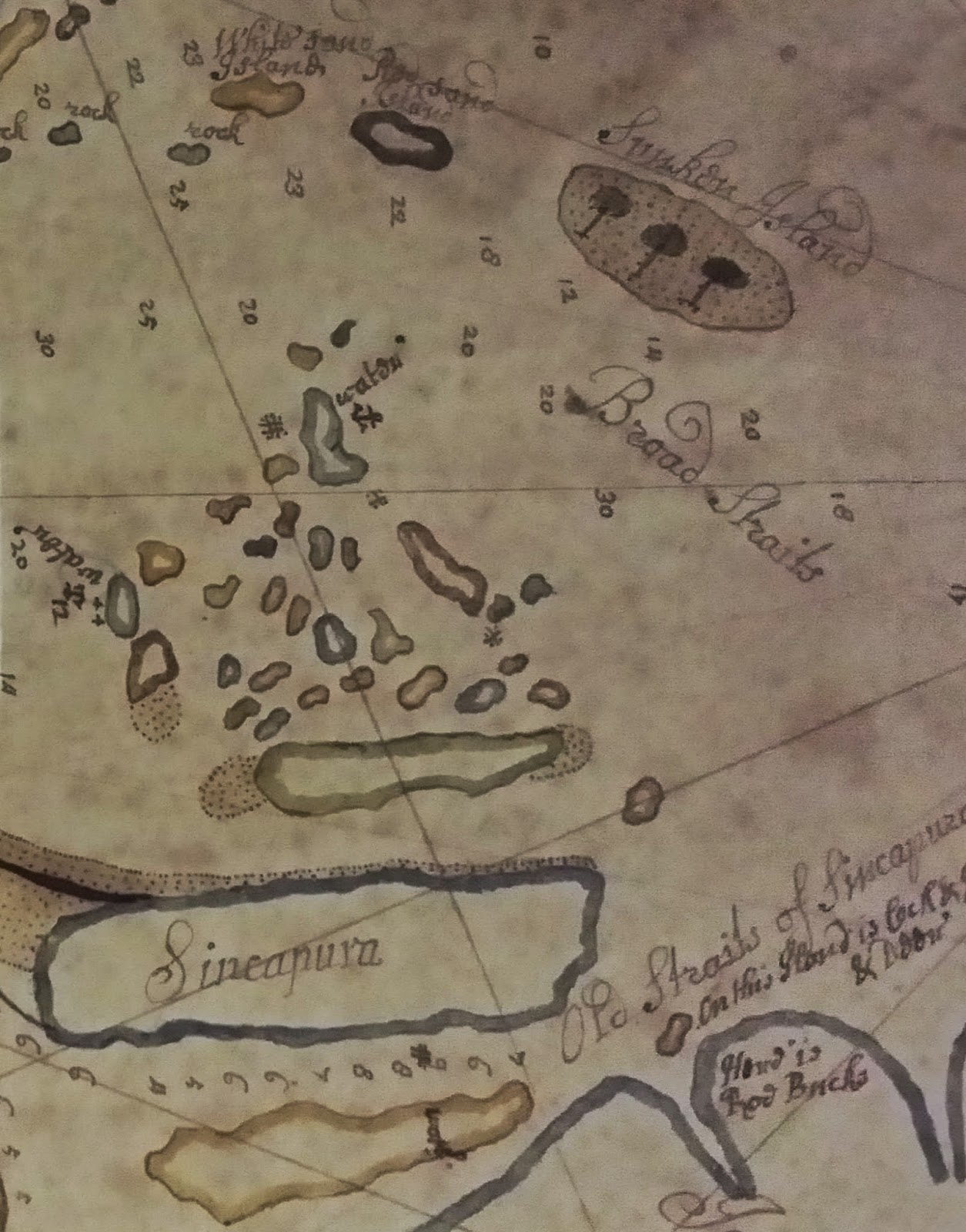 | ||
Figure 1. From a Hand-drawn chart of the southern portion of the Malay Peninsula, the Singapore Straits by Thomas Bowrey, 1690. Collection of the British Library, Add Ms. 5222-10. The chart has South on top and North at the bottom. Sincapura island is a featureless oblong apart from the sand banks emanating off the east end. Towards the top right is the feature with three trees on it, labelled Sunken Island. The Singapore Strait is labelled Broad Straits here. This map is on display in the LoGaS exhibition.
|

 |
Figure 3. From an untitled chart of the Strait of Singapore, circa 1675-1700. Collection of the Leiden University Library, 006-14-021. Tree island is near the centre of the figure. The island of the top right corner 't Lang Eylant (The Long Island) is Singapore island. This map is on display in the LoGaS exhibition.
|
 |
Figure 4. From Chart of the Riau and Lingga Archipelago, circa 1725. Collection of the Leiden University Library, 006-14-012. The round feature with three trees on it is labelled Boompjes Eilant (Trees island). This map is interesting as the island of Singapore is labelled Oude Straat Sincapura. This map was on display in the LoGaS exhibition till April 2015.
|
 |
Figure 5. From Jacques Nicolas Bellin's Carte reduite des detroits de Malaca, Sincapour, et du Gouverneur, 1755. Tree island is labelled as Banc aux Arbres. This map belongs to the NLB collection and is on display in the LoGaS exhibition.
|
 |
| Figure 6. From A.E. van Braam van Houckgeest's Nauwkeurige kaart van he oostlijk gedeelte van Straat Malacca, circa 1787. Collection of the Leiden University Library, 006-14-015. The feature with trees on the left is labeled Zaandplaat met de Boomen (sand bank with trees). On the right side is De Straat Gouverneur (Governor's Strait or Singapore Strait). This map belongs to the NLB collection and is on display in the LoGaS exhibition. |
This island came in several names: Tree Island, Boompjes Eilant (which is Tree island in Dutch), Bumkees Island (Corruption of the Dutch name), and Sunken island, to name a few.
The reason why this island was so clearly marked is because it was a traffic signpost of sorts to signify that one is approaching the safest (and most used) channel to go from the Straits of Malacca to the open seas of South china Sea, in the otherwise treacherous waters around Singapore island (Figure 7).
From the classic 19th century manual of sailing directions known as the Horsburgh's Sailing Instruction, the section on Singapore Straits reads [2]:SINGAPORE STRAIT, called Governor Strait, or New Strait by the French and Portuguese, may be considered to commence at Tree Island...
The Horsburgh's Sailing Instruction went on to describe this island...
...is a bank of rocks and sand very little elevated above the sea at high water, having on it two small trees or bushes, separated from each other.
 |
| Figure 7. Google map of the waters off the southern part of Singapore Island. On either side of the Singapore Straits are multitude of islands and sandbanks that were hazards to ships. |
This island is now known as Pulau Nipa. Up till less than twenty years ago, this above description would still apply to this island. It had a high tide area of 0.62 hectares (about a football field large) but would bloat to an approximate area of 60-hectare during low tide [3] (See Fig. 8).
 |
| Figure 8. The profile of Pulau Nipa during low tide (greenish-yellow) and during high tide (small specks in yellow). From the maritime chart Singapore and Indonesia Main Strait and Phillip Channel, 1990. |
 |
| Figure 9. How Pulau Nipa looked like before 2003 (looking southward). Picture Source. |
Nowadays, Singapore Strait is still heavily used. With better navigation technology, mariners no longer rely on spotting this island to know their directions into the Singapore Strait.
Now Tree island or Pulau Nipa should have retired from the annals of maritime history. But if you imagine it be an idyllic little island with a clump of nipah palms and coconut trees, and a sandy white beach (Fig. 9), you would be disappointed.
It gained prominence again not too long time ago. In 2003, there were concerns that the island was in danger of disappearing, because of sand dredging activities around it. As the island is part of the Indonesian archipelagic baseline on which the Singapore-Indonesia international boundary was to based on, it was deemed essential that this island remains an island. Presumably, Indonesia was afraid that Singapore may somehow not recognize a disappeared Pulau Nipa as part of the baseline (Despite the fact that part of the Singapore-Indonesia boundary had already been marked out in a 1973 treaty which used Pulau Nipa as part of the archipelagic base-line). Furthermore, the dredged sand was exported to Singapore for land reclamation work of Tuas and Jurong Island, which no doubt worried Indonesia.
Therefore, the Indonesian authorities embarked on an extensive land reclamation around Pulau Nipa to raise it permanently above sea level [4]. In any case, Pulau Nipa remained part of the archipelagic base-line used to extend the Singapore-Indonesia maritime boundary n 2009 [5]. Pulau Nipa now assumes a much more permanent existence (See Fig. 10 below), although hopefully in time to come, trees will flourish on it again.
 |
| Figure 10. How Pulau Nipa look like after the land reclamations (looking northward). Picture Source. |
References
[1] P. Borschberg, The Singapore and Melaka Straits: Violence, Security and Diplomacy in the 17th Century (NUS Press, Singapore, 2013) p. 36.
[2] James Horsburgh, The India directory, or, Directions for sailing to and from the East Indies, China, Australia, and the interjacent ports of Africa and South America: Originally compiled from the journals of the honourable company's ships, and from Observations and Remarks, resulting from the experience of twenty-one years in the Navigation of those seas.Volume Second. Seventh Edition. (Wm. H. Allen & Co., London, 1855), p. 266.
[3] "Kerasnya Nipa si Pulau Noktah Perbatasan RI", National Geographic Indonesia. link.
[4] "Indonesia restores key maritime baseline of Nipah Island: Foreign Ministry", Jakarta Post. Feb. 5th 2009. link
[5] "RI, Singapore sign maritime boundary agreement", Jakarta Post. March 11th 2009. link
