Summary: Mount Serapong is the highest point of Sentosa Island (which used to be known as Pulau Blakang Mati), and is also the highest hill in Singapore that is not on the main Singapore Island. Here, I summarize some history of this hill as they appear through maps and hydrographical charts.
| Figure 1. Excerpt from a 1819 map which may be the earliest map that shows Mt. Serapong, although still unmarked and unnamed. You can see (pointed out by the red arrow) the eastern end of "Island of Goa" which is today's Sentosa Island, and on it is marked a spot of Mt. Serapong [1]. |
Probably the first depiction of Mt Serapong on maps is on a map/hydrographic chart published in May 1819. Figure 1 shows an excerpt of that map, "Plan of Singapore Harbour February 1819" [1]. The map was prepared by Daniel Ross, who was part of the flotilla that brought Stamford Raffles in his attempt to found a trading post in this part of the world. That's when he landed and leased Singapore in late Jan./early Feb. 1819, thus beginning the British presence in Singapore. The map, with detailed depth sounding around the seas off the mouth of Singapore river and the southern coast of Singapore, was first published in May 1819 in the Calcutta Journal. Although still unmarked and unnamed. You can see the eastern end of "Island of Goa" which is today's Sentosa Island, and on it is marked a spot which is most likely Mt. Serapong.
 |
| Figure 2. "Sketch of the land round Singapore Harbor Feb 7 1819" [2,3]. A panoramic view of the seafront of Singapore from a position not too far out at sea from today's Marina Barrage. The rightmost top row of the sketch depicts today's Sentosa, and the highpoint marked out by the red arrow is Mt Serapong. Picture retrieved from [3]. |
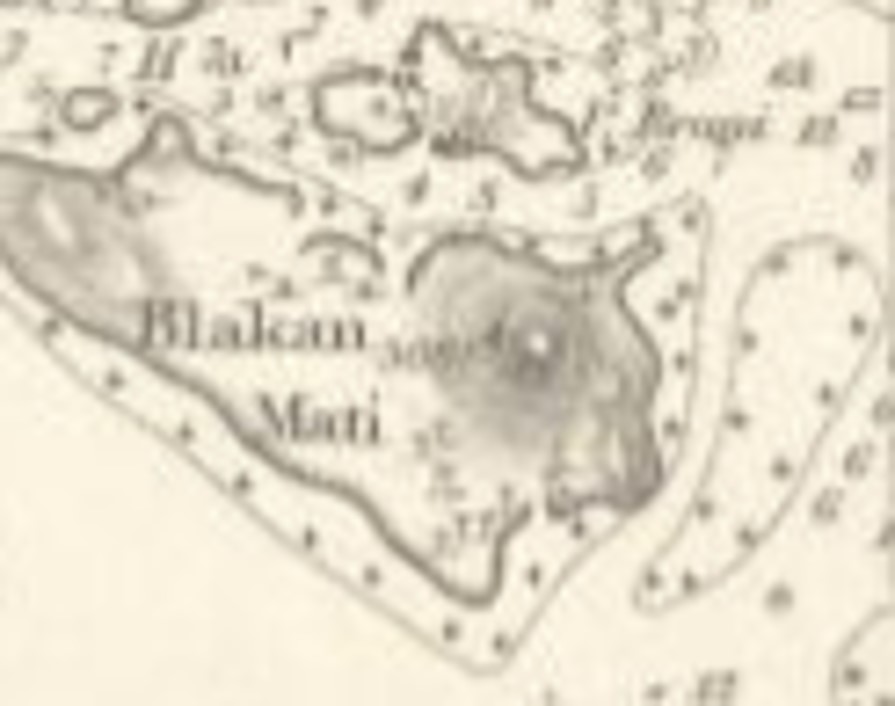
| Figure 3. 1827 chart by Daniel Ross entitled "A Plan of the Harbour near Singapore". Map is orientated approximately northwards towards the bottom. Mt. Serapong (still unnamed in this chart) is distinctively marked as the 'Highest hill on Blacan-mattee' [4]. The island in the middle is Pulau Brani. |
In a map made in 1827 by Daniel Ross, on a later visit to Singapore, Mt. Serapong (still unnamed in this chart) is distinctively marked as the 'Highest hill on Blacan-mattee' (Figure 3). Blacan-mattee or Blakang Mati, being the old name for Sentosa. This is from a hydrographic chart entitled "A Plan of the Harbour near Singapore" [4].
 |
| Figure 4. Excerpt from the 1846 Hydrographic Chart by S. Congalton and J.T. Thomson with probably the earliest mention of the height of Mount Serapong, at 308 ft [5]. |
The earliest mentions of the height of Mount Serapong that I can find so far is on a 1846 Hydrographic Chart by S. Congalton and J.T. Thomson (The 'Thomson' of Thomson Road, who was the the Straits Settlement's Government Surveyor then) [5] (See Figure 4), on which a height of 308 feet is indicated. At about the same time, on print, in an article published by James Low regarding the geology of Singapore in 1847, in which he writes about Blakang Mati was also mentioned its height, "This island is about 2 1/2 miles long with a maximum height of about 308 feet." [6].
 |
| Figure 5. 1851 Hydrographic Chart by J.T. Thomson with probably the earliest mention of the name "Mount Serapong" [7]. |
Mount Serapong finally got its name on a hydrographic chart published in 1851 entitled "New Harbour". The chart is prepared by J.T. Thomson [7]. On this chart however, was recorded a height of 302 feet for the height of Mount Serapong.
According to a facebook page written by the Urban Explorer of Singapore, The toponymic origin of 'Mt. Serapong' (and presumably a village and a creek with the same name) is a plant known as 'Seratong' (Tabernaemontana corymbosa).
Some time in the 1830s, a flagstaff was raised on Mount Serapong's summit which was later moved to Mount Faber in 1845 [8]. From 1878 onwards, Mount Serapong, which strategically looks over the channel that later became 'Keppel Harbour', started to see sustained military activities and constructions [9]. For people interested in this interesting bit of military history of Mount Serapong, do check out this two following references [8, 10]. These military activities and later development probably shaved a few meters off the its summit. The military armanents and constructions include a pair of late 19th century 8 inch guns, which were later replaced by 9.2 inch guns in 1910. In the 1930s, however, these guns became obsolete and were removed. The summit of Mt Serapong was then converted to become the Battery Observation Post (BOP) for the series of more modern 9.2 inch guns at the foot of Mt Serapong at the Fort Connaught battery (nowadays peacefully embedded in Tanjung golf course). By the 2nd World War, there was no longer any active artillery pieces on the summit, and the summit of Mt Serapong is occupied with a observation post. The remnants of this BOP is still slowly decaying on the summit of Mount Serapong (Figure 8 below).
 |
| Figure 6. Excerpt from "Map Of Singapore Island And Its Dependencies" (1898) where the height of Mount Serapong was written as 278 ft (84.7 m) [11]. |
On the 1898 edition of "Map Of the Island of Singapore And Its Dependencies" [11], the height of Mount Serapong was labelled as 278 ft (84.7 m). This height (either in feets or in metres) seems to appear as the height that was attached to Mount Serapong in most maps, all the way down to present day (In some cases, they were denoted as 277 ft).
However the 278 ft point does not denote the actual summit height, and could be just the trigonometrical height of a spot lower than the actual summit. On some more recent maps, such as the 1998 Singapore 1: 50,000 topographical map, apart from the trigonometrical point labelled as 85 m, there is also a benchmark height of 89.81m [12] which I surmise is the actual summit height of Mount Serapong. This makes Mount Serapong slightly lower than Telok Blangah Hill, but slightly higher than Bukit Peirce, thereby placing it at about 8th place on the "Tallest Peaks" list of Singapore.
 |
| Figure 7. Excerpt of the 1998 Topographical Map Of Singapore Island. There is a Trigonometrical Station height of 85 m and a Bench Mark height of 89.81 m [12]. |
 |
| Figure 8. The summit of Mount Serapong. The building you see is the Battery Observation Post (BOP) for the 9.2 inch guns near the foot of Mt Serapong, at the Fort Connaught battery. The actual summit of height ~90 m is immediately behind the building. For some details on how to get there, you may check this out this blog page (photo taken 15th Aug 2020). |
 |
| Figure 9. A view of Mount Serapong from the northwest. Photo taken from the Sentosa Gateway causeway (14th Dec 2020). |
References
[1] Plan of Singapore Harbour February 1819. (Daniel Ross. Calcutta Journal, Calcutta, 1819). Figure excerpted from Sotheby's Auction Website.
[2] Sketch of the Land round Singapore Harbour, 7 February 1819 (Collection of the National Archives (UK), 344/1307. Kew, U.K).
[3] M. Langdon and C.G. Kwa, "Notes on ‘Sketch of the Land round Singapore Harbour, 7 February 1819’". JMBRAS 83, 1 (2010), 1-7.
[4] A Plan of the Harbour near Singapore (Captn Dl Ross FRS Marine Surveyor General, 1827). Retrieved from he website of the UK National Maritime Museum Greenwich.
[5] This Survey Of The Straits Of Singapore, Is Respectfully Inscribed To The Honourable Colonel Butterworth, C.B. Governor of Prince of Wales Island, Singapore & Malacca, by his most obedient servants, Samuel Congalton, Comm: H. C. Steamer, Diana, J. T. Thomson, Government Surveyor, 1846. (James M. Richardson, London, 1846). Retrievable from National Archives of Singapore.
[6] J. Low, "Notes on the geological features of Singapore & the adjacent islands". Journal of the Indian Archipelago and Eastern Asia, Vol. 1 No. 3 (1847), 83-100.
[7] Singapore. New Harbour. Compiled by J. T. Thomson, Government Surveyor (Hydrographic Department, Admiralty, United Kingdom, 1851). Retrieved from National Archives of Sinagpore.
[8] Colonial Singapore: Archaeological vs. Historical Records. The Fort Serapong Case Study. Lim Chen Sian (M.A. thesis) (National University of Singapore, Singapore, 2007).
[9] Beyond Two Oceans, M.H. Murfett, J.N. Miksic, B.P. Farrell, and M.S. Chiang (Oxford University Press, Singapore, 1999) p 333.
[10] http://www.fortsiloso.com/batteries/wwII/serapong/serapong.htm
[11] Map Of the Island of Singapore And Its Dependencies. (A. Murray, 1898). Retrieved from National Archives of Singapore.
[12] Singapore 1:50,000 Series SMU 075, Edition 6 (Mapping Unit, Ministry of Defense, Singapore, 1998). Retrieved from https://libmaps.nus.edu.sg/