Summary: Bukit Mandai used to be the 4th highest hill on the island of Singapore. However, more recently, due to granite quarrying, it is now a gigantic hole in the ground. Since 2008, it is host to the Underground Ammunition Facility of the Singapore Armed Forces. It was one of the earliest hills in Singapore to be labelled on maps, and have gotten through several name changes and mistaken identities. Here, I summarize the hill to hole story of Bukit Mandai as they appear through maps and hydrographical charts.
 |
| Figure 1. Map captured from Google Map showing the location of where Bukit Mandai is (was). |
 |
| Figure 2. Excerpt from an early 1820s map showing the a lone feature in the interior of the island of Singapore [1]. The feature corresponds to the location of Bukit Mandai (See Figure 1) but is labelled 'Bukit Teemah' (see the zoom-in version provided in the inset). |
Within a square formed by Woodlands Road, Mandai Road, Bukit Timah Expressway (BKE) and Kranji Expressway (KJE) today, can be found several hills, or to be more accurate, the skeletal remains of hills. The most prominent one would be that which used to be Bukit Mandai (marked on Figure 1). It used to be a lofty 129 m and was the 4th highest hill in Singapore.
Bukit Mandai first appeared on maps very early on. On the very first map, made in the early 1820s, that had the shape of Singapore island more or less correct [1], was recorded only one major feature in the interior of Singapore. On Figure 1, you can see this feature of a hill (a zoom-in version provided in the inset). The position matches the location of Bukit Mandai. The interesting bit is that in this early map, the name of this hill feature (See the zoomed in inset in Figure 1) is labelled as 'Bukit Teemah' (a variation of 'Bukit Timah' undoubtedly)! Presumably, the hill when viewed from the survey ship circumnavigating the island, could have been misidentified as the current Bukit Timah [2]. However, I can also think of another possibility: Perhaps the feature identified is indeed originally called 'Bukit Teemah'. Somehow later, for whatever reason, the 'Bukit Timah' that we know today got the name instead. A wild speculation but food for thought.
 |
| Figure 3. Portion of the 1846 Hydrographic Chart by S. Congalton and J.T. Thomson. Bukit Mandai was labelled as "Bukit Kranjee" (Variation of the current toponym "Kranji") in this chart [3]. |
 |
| Figure 4. Portion of "Map Of The Old Straits, Or Silat Tambrau And The Creeks To The North Of Singapore Island" [4] dated 1848. Near the top, shows Bukit Mandai as "Bukit Ulu Mandi". It is the earliest (as far as I know) that the toponym "Mandai" (or variations of it) is attached to this hill. |
 |
| Figure 5. Portion of "Map Of Singapore Island And Its Dependencies" (1898) [5]. It shows "Bukit Mandi" with a height of 426 ft (129.8 m). The red lines denotes roads that today are known as, Mandai Road and Woodlands Road. |
On maps, the first indication of Bukit Mandai's height is in the 1898 edition of the "Map Of the Island of Singapore And Its Dependencies, at 426 ft (129.8 m). This map also indicates for the first time, the heights of Bukit Panjang, Bukit Gombak and Bukit Batok, amongst others (See an earlier blog here).
On the topographical maps from 1932 onwards, 'Bukit Mandai' at 422 ft (128.6 m) seems to become the official name and height of the hill.
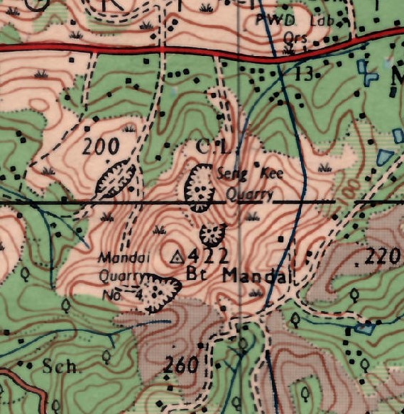 |
| Figure 6. Portion of the 1966 Topographical Map Of Singapore [7] showing the encroaching quarrying activities that would soon decimate Bukit Mandai. |
Bukit Mandai is part of the Bukit Timah Granite Formation. By 1940, there were already some quarrying activities in the Bukit Mandai area for its granite. Post war, by the early 1950s, these quarrying activities have become heavy enough that they appear on maps. On the 1953 topographical map, 'Seng Kee Quarry' can be seen just north of Bukit Mandai [6]. This is followed by the appearance of Mandai Quarry No. 4 in the 1966 topographical map [7] (See Figure 6). The encroaching quarrying activities soon decimated Bukit Mandai. On maps, by 1970, the 422 ft summit was no more.
 |
| Figure 7. Portion of the 1998 Topographical Map Of Singapore [8] showing the the big hole remnant of Bukit Mandai. The red triangle marks the spot where the summit used to be. |
In subsequent maps, the quarrying holes got larger and devoured the hill as well as the surrounding area. The 1998 topographical map shows the extent of the quarry hole (See Figure 7) [8]. I have marked on the map is also the original location of the summit (Red triangle in Figure 7).
 |
| Figure 8. View of the Quarry at Bukit Mandai. The view is southwards. In the background, you can pick out the Bukit Timah Ridge of the left, Bukit Batok, just left of centre and Bukit Panjang Ridge, right of centre. This photo is probably taken in the late 1990s to early 2000s. Picture taken from here. |
In the early 2000s, the Singapore Ministry of Defence repurposed the Bukit Mandai quarry area and built the ultra-modern Underground Ammunition Facility (UAF), which was completed and commissioned in 2008 [8]. Judging by the more recent topographical maps, the remnants of Bukit Mandai, at its highest is about 70-ish metres, pushing it way off the 'highest hills' list of Singapore.
 |
| Figure 9. View along the 'Pipeline' Trail. Bukit Mandai would have stood right there in the background, likely blocking the sky view here with lush green. The elevation of the photo is from about 60 m (photo taken 2021-06-24). |
Presently there is no public access to the remnants of Bukit Mandai, as obviously as the country's main military ammunition storage, it is strictly out of bounds. However you can still catch a imaginary glimpse of the hill if you hike along the so-called pipeline trail (in the stretch mostly running immediately on the west side of Bukit Timah Expressway, a couple of hundreds of metres south of Mandai Road). Figure 9 depict the view along the trail where Bukit Mandai would have stood right there in the immediately background, likely covering the sky view with lush green instead.
References
[1] Plan of the island of Singapore, including the new British Settlement and adjacent Islands. The settlement, environs, new harbour and adjacent islands surveyed by Lieutenant Colonel Farquhar. from NLB
[2] Mok Ly Yng "Franklin's Survey Map of Singapore", On Paper. Singapore before 1867, (National Library Board, Singapore, 2019), pg. 92.
[3] This Survey Of The Straits Of Singapore, Is Respectfully Inscribed To The Honourable Colonel Butterworth, C.B. Governor of Prince of Wales Island, Singapore & Malacca, by his most obedient servants, Samuel Congalton, Comm: H. C. Steamer, Diana, J. T. Thomson, Government Surveyor, 1846. (James M. Richardson, London, 1846). Retrievable from National Archives of Singapore. For Figure 1, I have used instead the updated 1855 edition, Retrievable from National Archives of Singapore.
[4] Map Of The Old Straits, Or Silat Tambrau And The Creeks To The North Of Singapore Island, (J. T. Thomson, 1848). Retrieved from National Archives of Singapore.
[5] Map Of the Island of Singapore And Its Dependencies. (A. Murray, 1898). Retrieved from National Archives of Singapore.
[6] Provisional Issue [1:25,000 Topographical Map of Singapore] (Survey Department Federation of Malaya, KL, 1953). "Historical Maps of Singapore, digitised by Department of Geography, National University of Singapore." https://libmaps.nus.edu.sg.
[7] Singapore Series L802, Edition 1-DNMM [1:25,000 Topographical Map] (Directorate of National Mapping Malaysia, Kuala Lumpur, 1966). "Historical Maps of Singapore, digitised by Department of Geography, National University of Singapore." https://libmaps.nus.edu.sg.
[8] Singapore Series SMU 075 Edition 6 [1:50,000 Topographical Map] (Mapping Unit, Ministry of Defense, Singapore, 1998). "Historical Maps of Singapore, digitised by Department of Geography, National University of Singapore." https://libmaps.nus.edu.sg.
[9] Teo Chee Hian "Commissioning of the Underground Ammunition Facility" Speech by Minister of Defence, 7 March 2008.