Friday 12 November 2021

Bukit Mandai II: From Hill to Hole II

Summary: Bukit Mandai II used to be the 9th highest hill on the island of Singapore. Granite quarrying since the 1920s has reduced the height of the hill and created a large hole. The remnants of this hill is now loosely known as Gali Batu. It sits behind the Gali Batu bus depot, not far from Woodlands Road.


Figure 1. Comparison between a 1939 map (Top) [1] and 2005 map (bottom) [2] showing the before and after of the quarrying activities which decimated Bukit Mandai II. In the bottom map, the red triangle marks the spot where the summit used to be.

This hill would have been the 9th tallest hill in Singapore if non of the Singapore's hills have had their head shaved off or quarried to non-existence. Bukit Mandai II originally had a height of about 305 feet (or about 93 m) and is situated about 1.2 km southwest of Bukit Mandai. The remnants of this hill is now loosely known as Gali Batu, which roughly means "Rock/Stone Digging" no doubt originating from its quarrying past. It sits behind the new Gali Batu bus terminal, not far from Woodlands Road.

On maps, it was an unnamed peak till the 1930s. The first mention that I can find of the name Bukit Mandai II came in the 1939 topographical map of Singapore [1]. 

Granite quarrying activities at Bukit Mandai II seems to have begun in 1925 [3]. This was the original 'Mandai Quarry' (Not to be confused with the later quarries associated with Bukit Mandai), and was owned by the Singapore Municipal Council and Singapore Harbour Board. The quarry was connected to the FMSR (Federated Malay States Railway) line and allows the quarried granite to be transported over to the Southern end of Singapore island for the construction needs around Singapore Harbour (Today's Harbourfront area). On the 1939 map in Fig. 1, is "Topham, Jones & Railton", who was the building contractor for the harbour construction (They were also the building contractor for the Causeway and many other civil and military works in Singapore then). 

The 290 feet marked on the 1939 map in Fig. 1 and labelled "Bt. Mandai II" is not the highest point. A higher point is situated at a point about 100 meters south of the 290 point. The contour line is at 300 feet, and so I will estimate this highpoint to be 305 feet. Throughout all the maps that I have come across, this highpoint has remained unlabeled, so technically I am wrong here to name this high point 'Bt. Mandai II', but that is just some academic detail.

Figure 2. Portion of the 1953 Topographical Map Of Singapore [4] showing the encroaching quarrying activities of "Mandai Quarry". The read triangle maps the summit of Bukit Mandai II, perilously close to the edge of the quarrying hole.  

From the 1953 map (Figure 2) [4], you can see the quarrying activity eating away the hill. By about 1970, the 305 feet highpoint is gone, and the 290 feet (88 m) became the highpoint of Bt. Gombak II, which you see in the 1975 map (Figure 3) [5]. Further quarrying ensures that that point itself eventually also disappeared about late 1980s to early 1990s.  

Figure 3. Portion of the 1953 Topographical Map Of Singapore [4] showing the encroaching quarrying activities of "Mandai Quarry". The read triangle maps the summit of Bukit Mandai II, perilously close to the edge of the quarrying hole.  

Nowadays, it is a rather scenic and secluded area (See Fig. 4). It is technically in a restricted area and is off-limit to casual visitors. 
Figure 4. View of the remnant of Bukit Mandai II. View from the west edge of the quarry 'hole'. 
       
Reference
[
1] Singapore & Johore, (Survey Department, Federated Malay States (F.M.S.) and Straits Settlements (S.S.), 1939). Retrieved from National Archives of Singapore.
[2] Singapore Series L802 Edition 10 SMU [1:25,000 Topographical Map] (Mapping Unit, Ministry of Defense, Singapore, 2005). Retrieved from "Historical Maps of Singapore, digitised by Department of Geography, National University of Singapore." https://libmaps.nus.edu.sg/  
[3] http://searail.malayanrailways.com/Industrial/industrial.htm
[4] Provisional Issue [1:25,000 Topographical Map of Singapore] (Survey Department Federation of Malaya, KL, 1953). Retrieved from "Historical Maps of Singapore, digitised by Department of Geography, National University of Singapore." https://libmaps.nus.edu.sg
[5] Singapore Series SMU 025 [1:25,000 Topographical Map] (Mapping Unit, Ministry of Defense, Singapore, 1975). Retrieved from "Historical Maps of Singapore, digitised by Department of Geography, National University of Singapore." https://libmaps.nus.edu.sg/


Monday 19 July 2021

Bukit Mandai: From Hill to Hole I

Summary: Bukit Mandai used to be the 4th highest hill on the island of Singapore. However, more recently, due to granite quarrying, it is now a gigantic hole in the ground. Since 2008, it is host to the Underground Ammunition Facility of the Singapore Armed Forces. It was one of the earliest hills in Singapore to be labelled on maps, and have gotten through several name changes and mistaken identities. Here, I summarize the hill to hole story of Bukit Mandai as they appear through maps and hydrographical charts.

Figure 1. Map captured from Google Map showing the location of where Bukit Mandai is (was).

Figure 2. Excerpt from an early 1820s map showing the a lone feature in the interior of the island of Singapore [1]. The feature corresponds to the location of Bukit Mandai (See Figure 1) but is labelled 'Bukit Teemah' (see the zoom-in version provided in the inset).

Within a square formed by Woodlands Road, Mandai Road, Bukit Timah Expressway (BKE) and Kranji Expressway (KJE) today, can be found several hills, or to be more accurate, the skeletal remains of hills. The most prominent one would be that which used to be Bukit Mandai (marked on Figure 1). It used to be a lofty 129 m and was the 4th highest hill in Singapore.

Bukit Mandai first appeared on maps very early on. On the very first map, made in the early 1820s, that had the shape of Singapore island more or less correct [1], was recorded only one major feature in the interior of Singapore. On Figure 1, you can see this feature of a hill (a zoom-in version provided in the inset). The position matches the location of Bukit Mandai. The interesting bit is that in this early map, the name of this hill feature (See the zoomed in inset in Figure 1) is labelled as 'Bukit Teemah' (a variation of 'Bukit Timah' undoubtedly)! Presumably, the hill when viewed from the survey ship circumnavigating the island, could have been misidentified as the current Bukit Timah [2]. However, I can also think of another possibility: Perhaps the feature identified is indeed originally called 'Bukit Teemah'. Somehow later, for whatever reason, the 'Bukit Timah' that we know today got the name instead. A wild speculation but food for thought.  

Figure 3. Portion of the 1846 Hydrographic Chart by S. Congalton and J.T. Thomson. Bukit Mandai was labelled as "Bukit Kranjee" (Variation of the current toponym "Kranji") in this chart [3].  

Bukit Mandai next appeared as 'Bukit Kranjee' (Variation of the current toponym "Kranji") in the 1846 Hydrographic Chart by S. Congalton and J.T. Thomson [3] (See Figure 3.). You may also observe that there is 'S(ungei). Mundai' directly north of the hill. 

Figure 4. Portion of "Map Of The Old Straits, Or Silat Tambrau And The Creeks To The North Of Singapore Island" [4] dated 1848. Near the top, shows Bukit Mandai as "Bukit Ulu Mandi". It is the earliest (as far as I know) that the toponym "Mandai" (or variations of it) is attached  to this hill. 

It was only in a 1848 map that "Mandai" (or variations of it) finally came to be attached to this hill as "Bukit Ulu Mandi" (See Figure 4). This map named "Map Of The Old Straits, Or Silat Tambrau And The Creeks To The North Of Singapore Island" was the result of surveying by J.T. Thomson, the Straits Settlement's Government Surveyor (and the 'Thomson' of 'Thomson Road'), in April 1848 [4].

Figure 5. Portion of "Map Of Singapore Island And Its Dependencies" (1898) [5]. It shows "Bukit Mandi" with a height of 426 ft (129.8 m). The red lines denotes roads that today are known as, Mandai Road and Woodlands Road.

On maps, the first indication of Bukit Mandai's height is in the 1898 edition of the "Map Of the Island of Singapore And Its Dependencies, at 426 ft (129.8 m). This map also indicates for the first time, the heights of Bukit Panjang, Bukit Gombak and Bukit Batok, amongst others (See an earlier blog here).   

On the topographical maps from 1932 onwards, 'Bukit Mandai' at 422 ft (128.6 m) seems to become the official name and height of the hill. 

Figure 6. Portion of the 1966 Topographical Map Of Singapore [7] showing the encroaching quarrying activities that would soon decimate Bukit Mandai. 

Bukit Mandai is part of the Bukit Timah Granite Formation. By 1940, there were already some quarrying activities in the Bukit Mandai area for its granite. Post war, by the early 1950s, these quarrying activities have become heavy enough that they appear on maps. On the 1953 topographical map, 'Seng Kee Quarry' can be seen just north of Bukit Mandai [6]. This is followed by the appearance of Mandai Quarry No. 4 in the 1966 topographical map [7] (See Figure 6). The encroaching quarrying activities soon decimated Bukit Mandai. On maps, by 1970, the 422 ft summit was no more.  

Figure 7. Portion of the 1998 Topographical Map Of Singapore [8] showing the the big hole remnant of Bukit Mandai. The red triangle marks the spot where the summit used to be. 

In subsequent maps, the quarrying holes got larger and devoured the hill as well as the surrounding area. The 1998 topographical map shows the extent of the quarry hole (See Figure 7) [8]. I have marked on the map is also the original location of the summit (Red triangle in Figure 7).  

Figure 8. View of the Quarry at Bukit Mandai. The view is southwards. In the background, you can pick out the Bukit Timah Ridge of the left, Bukit Batok, just left of centre and Bukit Panjang Ridge, right of centre. This photo is probably taken in the late 1990s to early 2000s. Picture taken from here

In the early 2000s, the Singapore Ministry of Defence repurposed the Bukit Mandai quarry area and built the ultra-modern Underground Ammunition Facility (UAF), which was completed and commissioned in 2008 [8]. Judging by the more recent topographical maps, the remnants of Bukit Mandai, at its highest is about 70-ish metres, pushing it way off the 'highest hills' list of Singapore.

Figure 9. View along the 'Pipeline' Trail. Bukit Mandai would have stood right there in the background, likely blocking the sky view here with lush green. The elevation of the photo is from about 60 m (photo taken 2021-06-24).   

Presently there is no public access to the remnants of Bukit Mandai, as obviously as the country's main military ammunition storage, it is strictly out of bounds. However you can still catch a imaginary glimpse of the hill if you hike along the so-called pipeline trail (in the stretch mostly running immediately on the west side of Bukit Timah Expressway, a couple of hundreds of metres south of Mandai Road). Figure 9 depict the view along the trail where Bukit Mandai would have stood right there in the immediately background, likely covering the sky view with lush green instead.

References 

[1] Plan of the island of Singapore, including the new British Settlement and adjacent Islands. The settlement, environs, new harbour and adjacent islands surveyed by Lieutenant Colonel Farquhar. from NLB

[2] Mok Ly Yng "Franklin's Survey Map of Singapore", On Paper. Singapore before 1867, (National  Library Board, Singapore, 2019), pg. 92.

[3] This Survey Of The Straits Of Singapore, Is Respectfully Inscribed To The Honourable Colonel Butterworth, C.B. Governor of Prince of Wales Island, Singapore & Malacca, by his most obedient servants, Samuel Congalton, Comm: H. C. Steamer, Diana, J. T. Thomson, Government Surveyor, 1846. (James M. Richardson, London, 1846). Retrievable from National Archives of Singapore. For Figure 1, I have used instead the updated 1855 edition, Retrievable from National Archives of Singapore.

[4] Map Of The Old Straits, Or Silat Tambrau And The Creeks To The North Of Singapore Island, (J. T. Thomson, 1848). Retrieved from National Archives of Singapore.

[5] Map Of the Island of Singapore And Its Dependencies. (A. Murray, 1898). Retrieved from National Archives of Singapore

[6]   Provisional Issue [1:25,000 Topographical Map of Singapore] (Survey Department Federation of Malaya, KL, 1953). "Historical Maps of Singapore, digitised by Department of Geography, National University of Singapore." https://libmaps.nus.edu.sg.

[7]  Singapore Series L802, Edition 1-DNMM [1:25,000 Topographical Map] (Directorate of National Mapping Malaysia, Kuala Lumpur, 1966). "Historical Maps of Singapore, digitised by Department of Geography, National University of Singapore." https://libmaps.nus.edu.sg.

[8]  Singapore Series SMU 075 Edition 6 [1:50,000 Topographical Map] (Mapping Unit, Ministry of Defense, Singapore, 1998). "Historical Maps of Singapore, digitised by Department of Geography, National University of Singapore." https://libmaps.nus.edu.sg.  

[9] Teo Chee Hian "Commissioning of the Underground Ammunition Facility" Speech by Minister of Defence, 7 March 2008. 

Monday 31 May 2021

Mount Serapong. Some early maps and views.

Summary: Mount Serapong is the highest point of Sentosa Island (which used to be known as Pulau Blakang Mati), and is also the highest hill in Singapore that is not on the main Singapore Island. Here, I summarize some history of this hill as they appear through maps and hydrographical charts. 

Figure 1. Excerpt from a 1819 map which may be the earliest map that shows Mt. Serapong, although still unmarked and unnamed. You can see (pointed out by the red arrow) the eastern end of "Island of Goa" which is today's Sentosa Island, and on it is marked a spot of Mt. Serapong [1].  

Probably the first depiction of Mt Serapong on maps is on a map/hydrographic chart published in May 1819. Figure 1 shows an excerpt of that map, "Plan of Singapore Harbour February 1819" [1]. The map was prepared by Daniel Ross, who was part of the flotilla that brought Stamford Raffles in his attempt to found a trading post in this part of the world. That's when he landed and leased Singapore in late Jan./early Feb. 1819, thus beginning the British presence in Singapore. The map, with detailed depth sounding around the seas off the mouth of Singapore river and the southern coast of Singapore, was first published in May 1819 in the Calcutta Journal. Although still unmarked and unnamed. You can see the eastern end of "Island of Goa" which is today's Sentosa Island, and on it is marked a spot which is most likely Mt. Serapong.   

Figure 2. "Sketch of the land round Singapore Harbor Feb 7 1819" [2,3]. A panoramic view of the seafront of Singapore from a position not too far out at sea from today's Marina Barrage. The rightmost top row of the sketch depicts today's Sentosa, and the highpoint marked out by the red arrow is Mt Serapong. Picture retrieved from [3].  

A very early sketch which was also made in February 1819, is probably the first picture of Mt. Serapong. This historical sketch entitled "Sketch of the land round Singapore Harbor Feb 7 1819" [2] is probably done by an officer on board a ship that was part of the flotilla which brought Raffles to Singapore (See above paragraph) [3]. The sketch portrays a view of the seafront view of Singapore from a position not too far off today's Marina Barrage. The sketch contains a view of Mount Serapong and Sentosa (Marked with a red arrow in Figure 2). If you are interested in more details regarding this sketch, please check out an earlier blog entry of mine here

Figure 3. 1827 chart by Daniel Ross entitled "A Plan of the Harbour near Singapore". Map is orientated approximately northwards towards the bottom. Mt. Serapong (still unnamed in this chart) is distinctively marked as the 'Highest hill on Blacan-mattee' [4]. The island in the middle is Pulau Brani.

In a map made in 1827 by Daniel Ross, on a later visit to Singapore, Mt. Serapong (still unnamed in this chart) is distinctively marked as the 'Highest hill on Blacan-mattee' (Figure 3).  Blacan-mattee  or Blakang Mati, being the old name for Sentosa. This is from a hydrographic chart entitled "A Plan of the Harbour near Singapore" [4]. 

Figure 4. Excerpt from the 1846 Hydrographic Chart by S. Congalton and J.T. Thomson with probably the earliest mention of the height of Mount Serapong, at 308 ft [5].

The earliest mentions of the height of Mount Serapong that I can find so far is on a 1846 Hydrographic Chart by S. Congalton and J.T. Thomson (The 'Thomson'  of Thomson Road, who was the the Straits Settlement's Government Surveyor then) [5] (See Figure 4), on which a height of 308 feet is indicated. At about the same time, on print, in an article published by James Low regarding the geology of Singapore in 1847, in which he writes about Blakang Mati was also mentioned its height, "This island is about 2 1/2 miles long with a maximum height of about 308 feet." [6]. 

Figure 5. 1851 Hydrographic Chart by J.T. Thomson with probably the earliest mention of the name "Mount Serapong" [7].

Mount Serapong finally got its name on a hydrographic chart published in 1851 entitled "New Harbour". The chart is prepared by J.T. Thomson [7]. On this chart however, was recorded a height of 302 feet for the height of Mount Serapong.   

According to a facebook page written by the Urban Explorer of Singapore, The toponymic origin of 'Mt. Serapong' (and presumably a village and a creek with the same name) is a plant known as 'Seratong' (Tabernaemontana corymbosa).  

Some time in the 1830s, a flagstaff was raised on Mount Serapong's summit which was later moved to Mount Faber in 1845 [8]. From 1878 onwards, Mount Serapong, which strategically looks over the channel that later became 'Keppel Harbour', started to see sustained military activities and constructions [9]. For people interested in this interesting bit of military history of Mount Serapong, do check out this two following  references [8, 10]. These military activities and later development probably shaved a few meters off the its summit. The military armanents and constructions include a pair of late 19th century 8 inch guns, which were later replaced by 9.2 inch guns in 1910. In the 1930s, however, these guns became obsolete and were removed. The summit of Mt Serapong was then converted to become the Battery Observation Post (BOP) for the series of more modern 9.2 inch guns at the foot of Mt Serapong at the Fort Connaught battery (nowadays peacefully embedded in Tanjung golf course). By the 2nd World War, there was no longer any active artillery pieces on the summit, and the summit of Mt Serapong is occupied with a observation post. The remnants of this BOP is still slowly decaying on the summit of Mount Serapong (Figure 8 below).  

Figure 6. Excerpt from "Map Of Singapore Island And Its Dependencies" (1898) where the height of Mount Serapong was written as 278 ft (84.7 m) [11].

On the 1898 edition of "Map Of the Island of Singapore And Its Dependencies" [11], the height of Mount Serapong was labelled as 278 ft (84.7 m). This height (either in feets or in metres) seems to appear as the height that was attached to Mount Serapong in most maps, all the way down to present day (In some cases, they were denoted as 277 ft).

However the 278 ft point does not denote the actual summit height, and could be just the trigonometrical height of a spot lower than the actual summit. On some more recent maps, such as the 1998 Singapore 1: 50,000 topographical map, apart from the trigonometrical point labelled as 85 m, there is also a benchmark height of 89.81m [12] which I surmise is the actual summit height of Mount Serapong. This makes Mount Serapong slightly lower than Telok Blangah Hill, but slightly higher than Bukit Peirce, thereby placing it at about 8th place on the "Tallest Peaks" list of Singapore

Figure 7. Excerpt of the 1998 Topographical Map Of Singapore Island. There is a Trigonometrical Station height of 85 m and a Bench Mark height of 89.81 m [12]. 


Figure 8. The summit of Mount Serapong. The building you see is the Battery Observation Post (BOP) for the 9.2 inch guns near the foot of Mt Serapong, at the Fort Connaught battery. The actual summit of height ~90 m is immediately behind the building. For some details on how to get there, you may check this out this blog page (photo taken 15th Aug 2020).


Figure 9. A view of Mount Serapong from the northwest. Photo taken from the Sentosa Gateway causeway (14th Dec 2020). 

References

[1] Plan of Singapore Harbour February 1819. (Daniel Ross. Calcutta Journal, Calcutta, 1819). Figure excerpted from Sotheby's Auction Website.  

[2] Sketch of the Land round Singapore Harbour, 7 February 1819 (Collection of the National Archives (UK), 344/1307. Kew, U.K).

[3] M. Langdon and C.G. Kwa, "Notes on ‘Sketch of the Land round Singapore Harbour, 7 February 1819’". JMBRAS 83, 1 (2010), 1-7.

[4] A Plan of the Harbour near Singapore (Captn Dl Ross FRS Marine Surveyor General, 1827). Retrieved from he website of the UK National Maritime Museum Greenwich.

[5] This Survey Of The Straits Of Singapore, Is Respectfully Inscribed To The Honourable Colonel Butterworth, C.B. Governor of Prince of Wales Island, Singapore & Malacca, by his most obedient servants, Samuel Congalton, Comm: H. C. Steamer, Diana, J. T. Thomson, Government Surveyor, 1846. (James M. Richardson, London, 1846). Retrievable from National Archives of Singapore

[6] J. Low, "Notes on the geological features of Singapore & the adjacent islands". Journal of the Indian Archipelago and Eastern Asia, Vol. 1 No. 3 (1847), 83-100.  

[7] Singapore. New Harbour. Compiled by J. T. Thomson, Government Surveyor (Hydrographic Department, Admiralty, United Kingdom, 1851). Retrieved from National Archives of  Sinagpore.

[8]  Colonial Singapore: Archaeological vs. Historical Records. The Fort Serapong Case Study. Lim Chen Sian (M.A. thesis) (National University of Singapore, Singapore, 2007).

[9]  Beyond Two Oceans, M.H. Murfett, J.N. Miksic, B.P. Farrell, and M.S. Chiang (Oxford University Press, Singapore, 1999) p 333.

[10] http://www.fortsiloso.com/batteries/wwII/serapong/serapong.htm

[11] Map Of the Island of Singapore And Its Dependencies. (A. Murray, 1898). Retrieved from National Archives of Singapore.

[12] Singapore  1:50,000 Series SMU 075, Edition 6 (Mapping Unit, Ministry of Defense, Singapore, 1998). Retrieved from https://libmaps.nus.edu.sg/ 

Saturday 6 March 2021

The Other Hills of Telok Blangah Hill

An early 20th century map, 'Map Of Singapore, published by the British War Office [1] contains several named hills in the Telok Blangah Hill area. I have list below some of them, together with their present names.

 
Figure 1. Excerpt of "Map Of Singapore" (1906, Corrections to 1914 ) [1] showing the subsidiary summits of Telok Blangah Hill (Labeled as Green Hill).  

The name on the map (Height) [whether the hill has been massively disfigured/disappeared]: Current name. And any further information.

Green Hill (Current Height: 93 m [2]): Telok Blangah Hill/Mt Faber II.  See an earlier blog for more information.

Coffee Hill (Original height: 85m [3]) [Disappeared]: Mt Faber II Service Reservoir. The reservoir seems to have been constructed sometime between 1978 and 1983. Current height at about 70 m.

Sugar Loaf Hill (Current Height: 77 m [2]): West end of Henderson Waves Bridge linking Telok Blangah Hill Park and Mount Faber Park.

Mount Washington & Chinaman's House (Current Height: 75m [3]): Alkaff Mansion (Figure 2). See an earlier blog for more information. A nearby summit (Today known as Picnic Hill in Telok Blangah Hill Park) of similar height seems also to be part of Mount Washington. 

Red Hill [Disappeared] : Mount Faber Green HDB estate, Telok Blangah Crescent. Is this the 'Red Hill' of the current Redhill? Could be. Although there are earlier mentions of a 'Red Hill' already in an 1852 "Map Of Singapore Island, And Its Dependencies" (More about this in a future post)  

Arab Hill [Disappeared] : The Interlace 

Queen's own Hill and King's own Hill [Disappeared] : Telok Blangah Heights HDB estate 


Figure 1. Alkaff Mansion. Although constructed in 1918, there was already another house at this location since at least the last 19th century. Since at least the early 1900s, this summit has been known as Mount Wahsington. 

Figure 2. View of Sugar Loaf Hill from the Henderson Waves Bridge.


Figure 3. Mt Faber II Service Reservoir. The reservoir seems to have been constructed sometime between 1978 and 1983 and Coffee Hill (Original height: 85m) was levelled. Current height ~70 m.


References

[1]  Map Of Singapore, (War Office, 1906 Corrections to March 1914) by Geographical Section, General Staff No. 2241. Retrieved from National Archives of Singapore.

[2]   Singapore  1:50,000 Series SMU 075, Edition 11 (Mapping Unit, Ministry of Defense, Singapore, 2017). 

[3]   Singapore Instrumental Plot - Alexandra Road and Jalan Bukit Merah [1:2,500 Topographical Map] (Produced by Fairey Surveys Ltd. for the Government of Singapore, Singapore, 1970). 


Saturday 23 January 2021

The Many 'Fabers' of 'Telok Blangah Hill'

Summary: Mount Faber, Telok Blangah Hill Park, Alkaff Mansion and Henderson Waves are famous landmarks in the Southern Part of Singapore. We explore the various different names and fables (pun intended) that have been attached to some of these hills through the ages. 

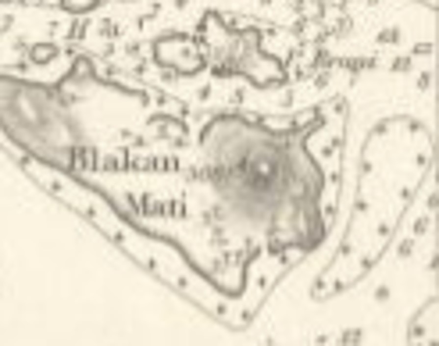
Figure 1. Portion of the 1846/1855 Hydrographic Chart by S. Congalton and J.T. Thomson [1]. Mt Faber denotes the whole ridge with the Flagstaff labelling the place where a signal station was constructed by Charles Edward Faber. The Flagstaff is not at the Mt Faber summit (Faber Point) but at a summit right beside the cable car station .

Mount Faber is of the highest hills in Singapore and one of the most well known landmarks in the southern part of Singapore, with its cable car links to Sentosa island. The cable car station however is not situated at Mount Faber's highest summit. Mount Faber summit, also known as Faber Point, is about 300 meters to the northwest of the cable car station.

The modern day Telok Blangah Hill (TBH) is situated in its namesake park, Telok Blangah Hill Park, and is about 1 km west-northwest of Mount Faber Summit. The summit is decorated (disfigured) with a series of attractive terraces with good views. TBH is surrounded by several subsidiary summits that host other well known landmarks, such as Alkaff Mansion and the western end of the Henderson Wave bridge.  

The current dividing line between Mount Faber and TBH seem to be Henderson Road. However, in the old days, these two hills and its many subsidiary summits seem to be known as being part of a long single hill ridge. We will try to look into the many names, old, new, disused and reused, throughout the ages. Since 'Telok Blangah Hill' is going to appear again and again and have different locations through the ages, to avoid confusion, I will use TBH to denote the current Telok Blangah Hill, and use the other variations as they appear in history.

As far as I can tell, the name 'Mount Faber' first appeared on maps in the 1846 Hydrographic Chart by S. Congalton and J.T. Thomson [1] (Shown in Figure 1 is an excerpted portion of the 1855 updated version of the 1846 map. I can't get a high enough resolution screen capture of the 1846 map).

Before 1845, the long ridge that includes today's Mount Faber and TBH was simply called "Tulloh Blangan Hills" or other variations of 'Telok Blangah Hills', after the area along the southern coast of Singapore (See Figure 2). In 1845, the hills were renamed Mount Faber after Charles Edward Faber of the Madras Engineers [link], who had overseen the building of a road leading to one of the summits of the hill (Not the Mount Faber Summit, but one near to the cable car station), and establishing there a signal station and flagstaff. 


Figure 2. Portion of the 1844 "Plan of Singapore Town and Adjoining Districts" by John Turnbull Thomson [2].

From 1850s onwards, the names "Tulloh Blangan Hills" or other variations of 'Telok Blangah Hills' gradually seem to fall out of favour, and the hills were increasingly being known as Mount Faber, and that includes the hill(s) that make up today's TBH. 'Telok Blangah' Hill did not quite disappear though... 

Figure 3. Excerpt of "Map Of the Island of Singapore And Its Dependencies" (1873) [3] showing the measured height of Mt. Faber at 291 ft (~88.7 m). This is probably the altitude of the summit that housed the signal station and flagstaff (right next to the current cable car station).

The height of Mt Faber was reported as 291 ft (~88.7 m) according to the 1873 edition of "Map Of Singapore Island And Its Dependencies" [3], although I suspect that that is the altitude measured for the summit that housed the signal station and flagstaff (right next to the current cable car station).

Figure 4. Excerpt of "Sketch plan of Mount Faber and Pasir Panjang" (1891) [4]. TBH appears as 'Green Hill'.  

The hill that is today's TBH made its mark on a map in "Sketch plan of Mount Faber and Pasir Panjang"  (Figure 4) [4], published in 1891 by H.E. McCallum, the surveyor general at that time. In this map, TBH is named 'Green Hill' with an altitude of 304 ft (92.7 m). In the same map, we also have "Mount Faber" covering the whole ridge and a more specific "Mt. Faber" denoting the position of the summit hosting the flagstaff and signal station, while the real Mount Faber summit is marked in red ink as 'Faber Redoubt" with an altitude of 343 ft. This map is an important documentation on the early defence of Singapore. 'Green Hill' appeared in several other maps up till the 1910s.

Figure 5. Excerpt of "Map Of Singapore Island And Its Dependencies" (1898) [5]. In this map, we have (Name on map = present location/name): Mt Faber 1 = Mount Faber Summit or Faber Point, Mt Faber 2 = TBH, Telok Blanga 1 = Bukit Purmei, Telok Blanga 2 = Henderson Park. 

The 1898 edition of the "Map Of the Island of Singapore And Its Dependencies" [5] contains several interesting details (See Figure 5), TBH appears in this map as 'Mt Faber 2' with an altitude of 312 ft (~95.1 m) , while on the same map, 'Mt Faber 1' denotes Faber Point, with an altitude of 350 ft (~106.7 m). Interestingly, there is also on the map, two shorter hills away from the main ridge, 'Telok Blanga 1' and 'Telok Blanga 2', at 113.5 ft (34.6 m) and 111 ft (33.8 m), respectively. Comparing with more recent maps, this peaks correspond to today's Bukit Purmei and Henderson Park, respectively.    

Another hill name of interest is 'Mount Washington'. Starting from sometime in the early 1900s, The name 'Mount Washington' started to be associated with a hill very near to TBH. In 'Map Of Singapore Town Within Municipal Limits 1906' (Figure 6) [6], Mount Washington denotes a spot, east of the summit of TBH (marked by a triangle in Figure 6) with a house on it. In 1906, the house shown is one probably belonging to Cheng Keng Lee. A newspaper advertisement in 1916 explicitly equate Mount Washington with this property [7]. The plot was later sold to the Alkaffs, and Alkaff mansion was then built there, which still stands there today. Numerous references of Alkaff mansion through the decades mention that it is located on Mount Washington.    

Figure 6. Excerpt from 'Map Of Singapore Town Within Municipal Limits 1906' (1909) [8], showing the location of Mt Washington and a house located there. The triangle to its left is where the summit of TBH is. Mount Faber summit on the bottom right corner of the figure.

There are also maps that label TBH as Mount Washington. For example, a 1918 'Map Showing The Swamps And The Chinese Burial Grounds Near Alexandra Road' by RH Young shows Mt Washington to be TBH [8]. Perhaps it is not really that surprising to extend the grand sounding name to this higher peak (relative to the location of the Alkaff Mansion). 

Sometime in the 1960s, TBH acquired an unofficial name as Qianfo Shan (千佛山), or 'Thousand Buddha Mountain'. TBH may have have acquired this unofficial name when a temple structure by the name of 'Thousand Buddha Hall' was built in the 1966 on the summit. An interesting short article on this can be found in this blog.

Officially it seems however, 'Mt Faber 2' continued to be the name of TBH for a very long time, it appeared on military topographical maps from 1939 [9] onwards, up till as recently as on the 1987 1:50000 Topographical Map Singapore [10]. In the 1980s, the new town of Telok Blangah was built on the foot of the whole of TBH/Mount Faber Ridge, and a new park "Telok Blangah Hill Park" was completed in 1988 [11] which included TBH. In the process, the 'Thousand Buddha Hall' was demolished, and a gazebo and terraces replaced the TBH summit area (See Fig. 7 and 8). Although there are no 'official' names on subsequent maps to denote this peak as 'Telok Blangah Hill', I assume here that the 'Hill' in 'Telok Blangah Hill Park' must have the same name as the park, and that TBH, Telok Blangah Hill 're-acquired' its current name with the creation of the namesake park in 1988.    

Figure 7. Photo of the summit of TBH. (from Google Map Street View)

Figure 8. View of the summit of TBH from Faber Point (Summit of Mount Faber)[Copyright H.-S. Tan].

To summarize, TBH has acquired many names throughout history and include: Green Hill, Mount Faber 2, Mount Washington, Qianfo Shan (Thousand Buddha Mountain) and finally, Telok Blangah Hill. 

References

[1]  This Survey Of The Straits Of Singapore, Is Respectfully Inscribed To The Honourable Colonel Butterworth, C.B. Governor of Prince of Wales Island, Singapore & Malacca, by his most obedient servants, Samuel Congalton, Comm: H. C. Steamer, Diana, J. T. Thomson, Government Surveyor, 1846. (James M. Richardson, London, 1846). Retrievable from National Archives of Singapore. For Figure 1, I have used instead the updated 1855 edition, Retrieved from National Archives of Singapore.

[2]  Plan of Singapore Town and Adjoining Districts from Actual Survey by John Turnbull Thomson, Governor Surveyor (J. T. Thomson, Singapore, 1844). Retrieved from National Archives of Singapore.

[3]  Map Of the Island of Singapore And Its Dependencies. (J.F.A. McNair, 1873). Retrieved from National Archives of Singapore.

[4]   Sketch plan of Mount Faber and Pasir Panjang. (H.E. McCallum, Colonial Engineer and Surveyor General, Straits Settlements, 1891). Retrieved from National Archives of Singapore.

[5]   Map Of the Island of Singapore And Its Dependencies. (A. Murray, 1898). Retrieved from National Archives of Singapore.

[6]  Map Of Singapore Town Within Municipal Limits 1906 (Alexander....Colonial Engineer and Surveyor General, Straits Settlements, 1909). Retrieved from National Archives of Singapore

[7]  The Singapore Free Press and Mercantile Advertiser, 7 January 1916, Page 4. (Retrieved from National Library of Singapore.

[8]  Map Showing The Swamps And The Chinese Burial Grounds Near Alexandra Road (R. H. Young, Chief Surveyor, Straits Settlements, 1918). Retrieved from National Archives of Singapore

[9]  Singapore and Johore Nos. 3L/11, 3L/12, 3L/15, 3L/16. [1:63,360 Topographical Map] (Surveyor General F.M.S. and S.S., 1939). Retrieved from National Archives of Singapore.

[10]  Singapore  1:50,000 Series SMU 075, Edition 4 (Mapping Unit, Ministry of Defense, Singapore, 1987). Retrieved from https://libmaps.nus.edu.sg/

[11]  Singapore 1989, Ed. Tan Han Hoe (Ministry of Communications and Information, Singapore 1989).